Maji geodata
Maji (Gansu) is a seat of a fourth-order administrative division; located in China in Asia/Shanghai (GMT+8) time zone. In our database, there are 1268 cities with bigger population. Compared to other cities in China, 75.9% of cities are located further ↓South; 91.5% of cities are located further →East and 95% of cities have lower elevation than Maji. Note1


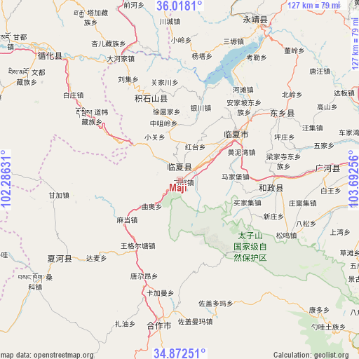
Maji GPS coordinates[2]
35° 26' 50.424" North, 102° 59' 21.948" East
| Map corner | latitude | longitude |
|---|---|---|
| Upper-left | 36.0181°, | 102.28631° |
| Center: | 35.44734°, | 102.98943° |
| Lower-right: | 34.87251°, | 103.69256° |
| Map W x H: | 127.4×127.4 km | = 79.2×79.2mi |
| max Lat: | 53.31946° ⇑24.1% North |
| Maji: | 35.44734° |
| min Lat: | ⇓75.9% South 18.22056° |
| min Long | Maji | max Long |
| 75.07348° | 102.98943° | 134.28917° |
| W 8.5%⇐ | ⇒91.5% E |
Elevation
Elevation of Maji is 2134 m = 7001 ft, and this is 1649.2 m = 5411 ft above average elevation for this country.
| Max E: |
5622 m = 18445 ft | 5% |
| Maji | 2134 m 7001 ft | |
| Avg. | 484.8 m = 1591 ft | |
Min E: |
-3 m = -10 ft | 95% |
See also: China elevation on elevation.city.
Geographical zone
Maji is located in North temperate zone (between Tropic of Cancer and the Arctic Circle). Distance of this Northern Tropic circle is 1335.5 km =829.8 mi to South.| Distance of | km | miles | from Maji |
|---|---|---|---|
| North Pole | 6065.7 | 3769.1 | to North |
| Arctic Circle | 3459.8 | 2149.8 | to North |
| Tropic Cancer | 1335.5 | 829.8 | to South |
| Equator | 3941.4 | 2449.1 | to South |


Nearby cities:
15 places around Maji: (largest is in red/bold)
• Biashizang
17.6 km =10.9 mi,  345°
345°
• Guogan
22.8 km =14.2 mi,  0°
0°
• Hanji
5.4 km =3.4 mi, 3°
• Juiji
23.1 km =14.4 mi, 346°
• Linxia Chengguanzhen
26 km =16.2 mi,  49°
49°
• Madang
23 km =14.3 mi,  233°
233°
• Manisi
9 km =5.6 mi,  321°
321°
• Monigou
4.2 km =2.6 mi,  301°
301°
• Qu’ao
13.5 km =8.4 mi, 228°
• Wangge’ertang
26.9 km =16.7 mi,  211°
211°
• Xiaoguan
17.6 km =10.9 mi,  329°
329°
• Xuhujia
24.4 km =15.2 mi, 351°
• Yingtan
14.1 km =8.8 mi, 353°
• Zhangzigou
8.7 km =5.4 mi, 348°
• Zhongzuiling
21.1 km =13.1 mi,  344°
344°
Sources, notices
• [Note1] Compared only with cities in China existing in our database
• [Src1] Map data: © OpenStreetMap contributors (CC-BY-SA)
• [Src2] Other city data from geonames.org with taken over terms of usage.
• [Src3] Geographical zone / Annual Mean Temperature by Robert A. Rohde @ Wikipedia
