Zhangzigou geodata
Zhangzigou (Gansu) is a seat of a fourth-order administrative division; located in China in Asia/Shanghai (GMT+8) time zone. In our database, there are 1268 cities with bigger population. Compared to other cities in China, 76.1% of cities are located further ↓South; 91.6% of cities are located further →East and 95.4% of cities have lower elevation than Zhangzigou. Note1


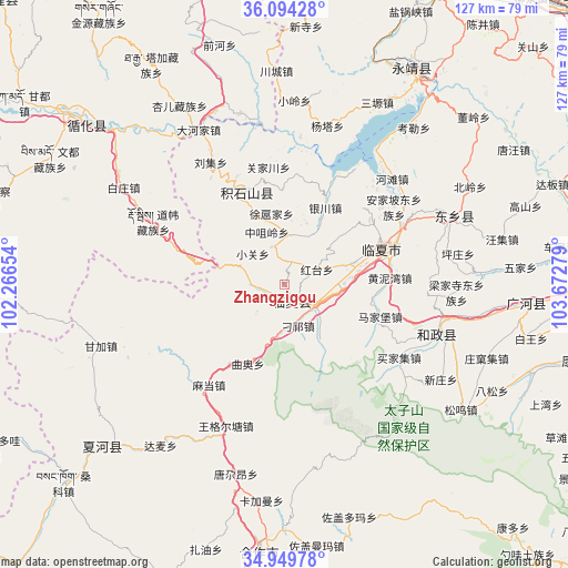
Zhangzigou GPS coordinates[2]
35° 31' 26.652" North, 102° 58' 10.776" East
| Map corner | latitude | longitude |
|---|---|---|
| Upper-left | 36.09428°, | 102.26654° |
| Center: | 35.52407°, | 102.96966° |
| Lower-right: | 34.94978°, | 103.67279° |
| Map W x H: | 127.3×127.3 km | = 79.1×79.1mi |
| max Lat: | 53.31946° ⇑23.9% North |
| Zhangzigou: | 35.52407° |
| min Lat: | ⇓76.1% South 18.22056° |
| min Long | Zhangzigou | max Long |
| 75.07348° | 102.96966° | 134.28917° |
| W 8.4%⇐ | ⇒91.6% E |
Elevation
Elevation of Zhangzigou is 2262 m = 7421 ft, and this is 1777.2 m = 5831 ft above average elevation for this country.
| Max E: |
5622 m = 18445 ft | 4.6% |
| Zhangzigou | 2262 m 7421 ft | |
| Avg. | 484.8 m = 1591 ft | |
Min E: |
-3 m = -10 ft | 95.4% |
See also: China elevation on elevation.city.
Geographical zone
Zhangzigou is located in North temperate zone (between Tropic of Cancer and the Arctic Circle). Distance of this Northern Tropic circle is 1344 km =835.1 mi to South.| Distance of | km | miles | from Zhangzigou |
|---|---|---|---|
| North Pole | 6057.2 | 3763.8 | to North |
| Arctic Circle | 3451.3 | 2144.5 | to North |
| Tropic Cancer | 1344 | 835.1 | to South |
| Equator | 3949.9 | 2454.4 | to South |


Nearby cities:
15 places around Zhangzigou: (largest is in red/bold)
• Biashizang
8.9 km =5.5 mi,  342°
342°
• Guogan
14.4 km =8.9 mi,  8°
8°
• Hanji
3.8 km =2.4 mi,  146°
146°
• Hulinjia
22.6 km =14 mi,  352°
352°
• Juiji
14.4 km =8.9 mi, 346°
• Linxia Chengguanzhen
23 km =14.3 mi,  68°
68°
• Maji
8.7 km =5.4 mi,  168°
168°
• Manisi
4.2 km =2.6 mi,  248°
248°
• Monigou
6.6 km =4.1 mi,  195°
195°
• Qu’ao
19.4 km =12.1 mi,  205°
205°
• Xiaoguan
9.7 km =6 mi,  313°
313°
• Xuhujia
15.7 km =9.8 mi, 354°
• Yingtan
5.5 km =3.4 mi,  1°
1°
• Zhaizigou
18.7 km =11.6 mi, 337°
• Zhongzuiling
12.5 km =7.8 mi, 341°
Sources, notices
• [Note1] Compared only with cities in China existing in our database
• [Src1] Map data: © OpenStreetMap contributors (CC-BY-SA)
• [Src2] Other city data from geonames.org with taken over terms of usage.
• [Src3] Geographical zone / Annual Mean Temperature by Robert A. Rohde @ Wikipedia
