Qu’ao geodata
Qu’ao (Gansu) is a seat of a fourth-order administrative division; located in China in Asia/Shanghai (GMT+8) time zone. In our database, there are 1268 cities with bigger population. Compared to other cities in China, 75.7% of cities are located further ↓South; 91.7% of cities are located further →East and 95.6% of cities have lower elevation than Qu’ao. Note1


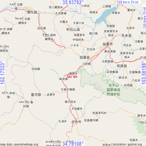
Qu’ao GPS coordinates[2]
35° 21' 59.364" North, 102° 52' 42.42" East
| Map corner | latitude | longitude |
|---|---|---|
| Upper-left | 35.93782°, | 102.17533° |
| Center: | 35.36649°, | 102.87845° |
| Lower-right: | 34.79108°, | 103.58158° |
| Map W x H: | 127.5×127.5 km | = 79.2×79.2mi |
| max Lat: | 53.31946° ⇑24.3% North |
| Qu’ao: | 35.36649° |
| min Lat: | ⇓75.7% South 18.22056° |
| min Long | Qu’ao | max Long |
| 75.07348° | 102.87845° | 134.28917° |
| W 8.3%⇐ | ⇒91.7% E |
Elevation
Elevation of Qu’ao is 2369 m = 7772 ft, and this is 1884.2 m = 6182 ft above average elevation for this country.
| Max E: |
5622 m = 18445 ft | 4.4% |
| Qu’ao | 2369 m 7772 ft | |
| Avg. | 484.8 m = 1591 ft | |
Min E: |
-3 m = -10 ft | 95.6% |
See also: China elevation on elevation.city.
Geographical zone
Qu’ao is located in North temperate zone (between Tropic of Cancer and the Arctic Circle). Distance of this Northern Tropic circle is 1326.5 km =824.2 mi to South.| Distance of | km | miles | from Qu’ao |
|---|---|---|---|
| North Pole | 6074.7 | 3774.6 | to North |
| Arctic Circle | 3468.8 | 2155.4 | to North |
| Tropic Cancer | 1326.5 | 824.2 | to South |
| Equator | 3932.4 | 2443.5 | to South |


Nearby cities:
15 places around Qu’ao: (largest is in red/bold)
• Biashizang
26.6 km =16.5 mi,  12°
12°
• Damai
26.8 km =16.7 mi,  226°
226°
• Hanji
17.7 km =11 mi,  35°
35°
• Kajiadao
29.6 km =18.4 mi,  159°
159°
• Kajiaman
31.1 km =19.3 mi,  174°
174°
• Madang
9.6 km =6 mi,  241°
241°
• Maji
13.5 km =8.4 mi,  48°
48°
• Manisi
16.6 km =10.3 mi,  15°
15°
• Monigou
12.9 km =8 mi,  29°
29°
• Tangga’an
25 km =15.5 mi,  185°
185°
• Wangge’ertang
14.5 km =9 mi,  196°
196°
• Xiaoguan
24.3 km =15.1 mi,  2°
2°
• Yingtan
24.5 km =15.2 mi, 20°
• Zhangzigou
19.4 km =12.1 mi, 25°
• Zhongzuiling
29.7 km =18.5 mi, 8°
Sources, notices
• [Note1] Compared only with cities in China existing in our database
• [Src1] Map data: © OpenStreetMap contributors (CC-BY-SA)
• [Src2] Other city data from geonames.org with taken over terms of usage.
• [Src3] Geographical zone / Annual Mean Temperature by Robert A. Rohde @ Wikipedia
