Ge’ao geodata
Ge’ao (Jiangxi) is a seat of a fourth-order administrative division; located in China in Asia/Shanghai (GMT+8) time zone. In our database, there are 1268 cities with bigger population. Compared to other cities in China, 81.3% of cities are located further ↑North; 58.3% of cities are located further ←West and 50.2% of cities have lower elevation than Ge’ao. Note1


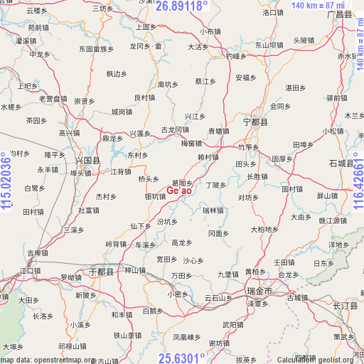
Ge’ao GPS coordinates[2]
26° 15' 44.46" North, 115° 43' 24.528" East
| Map corner | latitude | longitude |
|---|---|---|
| Upper-left | 26.89118°, | 115.02036° |
| Center: | 26.26235°, | 115.72348° |
| Lower-right: | 25.6301°, | 116.42661° |
| Map W x H: | 140.2×140.2 km | = 87.1×87.1mi |
| max Lat: | 53.31946° ⇑81.3% North |
| Ge’ao: | 26.26235° |
| min Lat: | ⇓18.7% South 18.22056° |
| min Long | Ge’ao | max Long |
| 75.07348° | 115.72348° | 134.28917° |
| W 58.3%⇐ | ⇒41.7% E |
Elevation
Elevation of Ge’ao is 167 m = 548 ft, and this is 317.8 m = 1043 ft below average elevation for this country.
| Max E: |
5622 m = 18445 ft | 49.8% |
| Avg. | 484.8 m = 1591 ft | |
| Ge’ao | 167 m = 548 ft | |
Min E: |
-3 m = -10 ft | 50.2% |
See also: China elevation on elevation.city.
Geographical zone
Ge’ao is located in North temperate zone (between Tropic of Cancer and the Arctic Circle). Distance of this Northern Tropic circle is 314.2 km =195.2 mi to South.| Distance of | km | miles | from Ge’ao |
|---|---|---|---|
| North Pole | 7087 | 4403.7 | to North |
| Arctic Circle | 4481.1 | 2784.4 | to North |
| Tropic Cancer | 314.2 | 195.2 | to South |
| Equator | 2920.1 | 1814.5 | to South |


Nearby cities:
15 places around Ge’ao: (largest is in red/bold)
• Dingbei
13 km =8.1 mi,  91°
91°
• Dongcun
20.4 km =12.7 mi,  303°
303°
• Fenkeng
16 km =9.9 mi,  201°
201°
• Gangmian
23.9 km =14.9 mi,  144°
144°
• Gaolong
22.9 km =14.2 mi,  180°
180°
• Gulonggang
20.8 km =12.9 mi,  352°
352°
• Huangshi
21.2 km =13.2 mi,  96°
96°
• Jiangbei
24.4 km =15.2 mi,  280°
280°
• Laicun
13.4 km =8.3 mi,  45°
45°
• Ma’an
18.5 km =11.5 mi,  251°
251°
• Meiyao
15.5 km =9.6 mi,  12°
12°
• Qingtang
24.2 km =15 mi,  35°
35°
• Ruilin
15.8 km =9.8 mi,  131°
131°
• Xianxia
23 km =14.3 mi,  223°
223°
• Yinkeng
12.1 km =7.5 mi,  244°
244°
Sources, notices
• [Note1] Compared only with cities in China existing in our database
• [Src1] Map data: © OpenStreetMap contributors (CC-BY-SA)
• [Src2] Other city data from geonames.org with taken over terms of usage.
• [Src3] Geographical zone / Annual Mean Temperature by Robert A. Rohde @ Wikipedia
