Yuanmao geodata
Yuanmao (Gansu) is a seat of a fourth-order administrative division; located in China in Asia/Shanghai (GMT+8) time zone. In our database, there are 1268 cities with bigger population. Compared to other cities in China, 78.1% of cities are located further ↓South; 84.5% of cities are located further →East and 92.8% of cities have lower elevation than Yuanmao. Note1


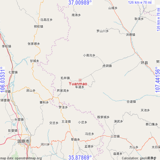
Yuanmao GPS coordinates[2]
36° 26' 46.86" North, 106° 44' 18.348" East
| Map corner | latitude | longitude |
|---|---|---|
| Upper-left | 37.00989°, | 106.03531° |
| Center: | 36.44635°, | 106.73843° |
| Lower-right: | 35.87869°, | 107.44156° |
| Map W x H: | 125.8×125.8 km | = 78.2×78.2mi |
| max Lat: | 53.31946° ⇑21.9% North |
| Yuanmao: | 36.44635° |
| min Lat: | ⇓78.1% South 18.22056° |
| min Long | Yuanmao | max Long |
| 75.07348° | 106.73843° | 134.28917° |
| W 15.5%⇐ | ⇒84.5% E |
Elevation
Elevation of Yuanmao is 1679 m = 5509 ft, and this is 1194.2 m = 3918 ft above average elevation for this country.
| Max E: |
5622 m = 18445 ft | 7.2% |
| Yuanmao | 1679 m 5509 ft | |
| Avg. | 484.8 m = 1591 ft | |
Min E: |
-3 m = -10 ft | 92.8% |
See also: China elevation on elevation.city.
Geographical zone
Yuanmao is located in North temperate zone (between Tropic of Cancer and the Arctic Circle). Distance of this Northern Tropic circle is 1446.5 km =898.8 mi to South.| Distance of | km | miles | from Yuanmao |
|---|---|---|---|
| North Pole | 5954.6 | 3700 | to North |
| Arctic Circle | 3348.7 | 2080.8 | to North |
| Tropic Cancer | 1446.5 | 898.8 | to South |
| Equator | 4052.5 | 2518.1 | to South |


Nearby cities:
15 places around Yuanmao: (largest is in red/bold)
• Beiwa
36.1 km =22.4 mi,  198°
198°
• Chedao
5.1 km =3.2 mi,  183°
183°
• Gaotai
32.3 km =20.1 mi,  270°
270°
• Heping
36 km =22.4 mi,  110°
110°
• Hudong
23.8 km =14.8 mi,  61°
61°
• Lujiawan
16 km =9.9 mi,  240°
240°
• Luowa
25 km =15.5 mi,  214°
214°
• Luping
30.3 km =18.8 mi, 109°
• Maojing
12 km =7.5 mi,  279°
279°
• Maqu
24.8 km =15.4 mi,  256°
256°
• Xiaocha
32.8 km =20.4 mi, 176°
• Xiaonangou
21 km =13 mi,  19°
19°
• Xinshan
33.8 km =21 mi,  252°
252°
• Yinjiacheng
33.9 km =21.1 mi,  147°
147°
• Zhaike
33 km =20.5 mi, 238°
Sources, notices
• [Note1] Compared only with cities in China existing in our database
• [Src1] Map data: © OpenStreetMap contributors (CC-BY-SA)
• [Src2] Other city data from geonames.org with taken over terms of usage.
• [Src3] Geographical zone / Annual Mean Temperature by Robert A. Rohde @ Wikipedia
