Xinshan geodata
Xinshan (Ningxia Hui Autonomous Region) is a seat of a fourth-order administrative division; located in China in Asia/Shanghai (GMT+8) time zone. In our database, there are 1268 cities with bigger population. Compared to other cities in China, 77.9% of cities are located further ↓South; 85.5% of cities are located further →East and 94.5% of cities have lower elevation than Xinshan. Note1


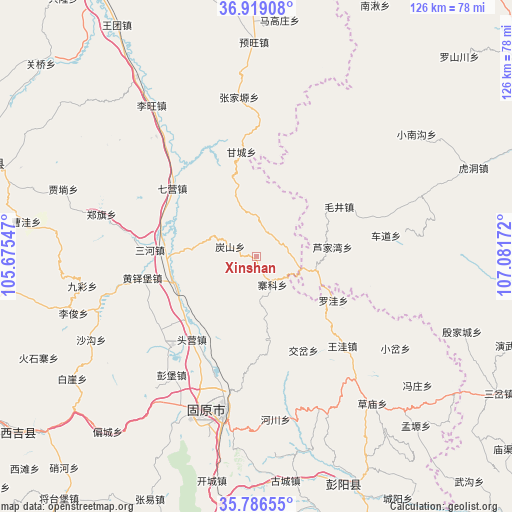
Xinshan GPS coordinates[2]
36° 21' 17.532" North, 106° 22' 42.924" East
| Map corner | latitude | longitude |
|---|---|---|
| Upper-left | 36.91908°, | 105.67547° |
| Center: | 36.35487°, | 106.37859° |
| Lower-right: | 35.78655°, | 107.08172° |
| Map W x H: | 125.9×125.9 km | = 78.2×78.2mi |
| max Lat: | 53.31946° ⇑22.1% North |
| Xinshan: | 36.35487° |
| min Lat: | ⇓77.9% South 18.22056° |
| min Long | Xinshan | max Long |
| 75.07348° | 106.37859° | 134.28917° |
| W 14.5%⇐ | ⇒85.5% E |
Elevation
Elevation of Xinshan is 1955 m = 6414 ft, and this is 1470.2 m = 4823 ft above average elevation for this country.
| Max E: |
5622 m = 18445 ft | 5.5% |
| Xinshan | 1955 m 6414 ft | |
| Avg. | 484.8 m = 1591 ft | |
Min E: |
-3 m = -10 ft | 94.5% |
See also: China elevation on elevation.city.
Geographical zone
Xinshan is located in North temperate zone (between Tropic of Cancer and the Arctic Circle). Distance of this Northern Tropic circle is 1436.4 km =892.5 mi to South.| Distance of | km | miles | from Xinshan |
|---|---|---|---|
| North Pole | 5964.8 | 3706.4 | to North |
| Arctic Circle | 3358.9 | 2087.1 | to North |
| Tropic Cancer | 1436.4 | 892.5 | to South |
| Equator | 4042.3 | 2511.8 | to South |


Nearby cities:
15 places around Xinshan: (largest is in red/bold)
• Gaotai
10.4 km =6.5 mi,  359°
359°
• Gongbailiang
6.7 km =4.2 mi,  289°
289°
• Guanting
21.6 km =13.4 mi,  171°
171°
• Heicheng
26.2 km =16.3 mi,  273°
273°
• Jiaocha
26 km =16.2 mi,  153°
153°
• Lujiawan
18.5 km =11.5 mi,  83°
83°
• Luowa
21 km =13 mi,  120°
120°
• Maojing
23.8 km =14.8 mi,  59°
59°
• Maqu
9.2 km =5.7 mi, 60°
• Qiying
26.4 km =16.4 mi,  308°
308°
• Sanying
21.6 km =13.4 mi,  247°
247°
• Tanshan
7.1 km =4.4 mi, 290°
• Touying
25.5 km =15.8 mi,  214°
214°
• Yanglang
23.6 km =14.7 mi,  232°
232°
• Zhaike
8.1 km =5 mi, 150°
Sources, notices
• [Note1] Compared only with cities in China existing in our database
• [Src1] Map data: © OpenStreetMap contributors (CC-BY-SA)
• [Src2] Other city data from geonames.org with taken over terms of usage.
• [Src3] Geographical zone / Annual Mean Temperature by Robert A. Rohde @ Wikipedia
