Jiaocha geodata
Jiaocha (Ningxia Hui Autonomous Region) is a seat of a fourth-order administrative division; located in China in Asia/Shanghai (GMT+8) time zone. In our database, there are 1268 cities with bigger population. Compared to other cities in China, 77.6% of cities are located further ↓South; 85.1% of cities are located further →East and 93.3% of cities have lower elevation than Jiaocha. Note1


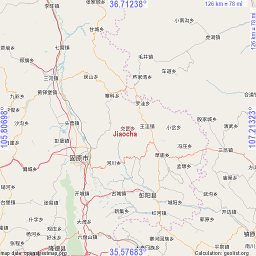
Jiaocha GPS coordinates[2]
36° 8' 47.976" North, 106° 30' 36.36" East
| Map corner | latitude | longitude |
|---|---|---|
| Upper-left | 36.71238°, | 105.80698° |
| Center: | 36.14666°, | 106.5101° |
| Lower-right: | 35.57683°, | 107.21323° |
| Map W x H: | 126.3×126.3 km | = 78.5×78.5mi |
| max Lat: | 53.31946° ⇑22.4% North |
| Jiaocha: | 36.14666° |
| min Lat: | ⇓77.6% South 18.22056° |
| min Long | Jiaocha | max Long |
| 75.07348° | 106.5101° | 134.28917° |
| W 14.9%⇐ | ⇒85.1% E |
Elevation
Elevation of Jiaocha is 1758 m = 5768 ft, and this is 1273.2 m = 4177 ft above average elevation for this country.
| Max E: |
5622 m = 18445 ft | 6.7% |
| Jiaocha | 1758 m 5768 ft | |
| Avg. | 484.8 m = 1591 ft | |
Min E: |
-3 m = -10 ft | 93.3% |
See also: China elevation on elevation.city.
Geographical zone
Jiaocha is located in North temperate zone (between Tropic of Cancer and the Arctic Circle). Distance of this Northern Tropic circle is 1413.2 km =878.1 mi to South.| Distance of | km | miles | from Jiaocha |
|---|---|---|---|
| North Pole | 5987.9 | 3720.7 | to North |
| Arctic Circle | 3382 | 2101.5 | to North |
| Tropic Cancer | 1413.2 | 878.1 | to South |
| Equator | 4019.1 | 2497.4 | to South |


Nearby cities:
15 places around Jiaocha: (largest is in red/bold)
• Beiwa
9 km =5.6 mi,  95°
95°
• Caomiao
21.4 km =13.3 mi,  127°
127°
• Chengjiao
24.6 km =15.3 mi,  231°
231°
• Dongjiao
25.4 km =15.8 mi, 231°
• Gonghe
15.5 km =9.6 mi,  236°
236°
• Guanting
8.8 km =5.5 mi,  282°
282°
• Lujiawan
26.2 km =16.3 mi,  14°
14°
• Luowa
14.2 km =8.8 mi,  26°
26°
• Shicha
15.8 km =9.8 mi,  166°
166°
• Touying
26.3 km =16.3 mi,  274°
274°
• Xiaocha
22.4 km =13.9 mi,  88°
88°
• Xiawangwa
12.2 km =7.6 mi,  111°
111°
• Xijiao
26 km =16.2 mi, 234°
• Xinshan
26 km =16.2 mi,  333°
333°
• Zhaike
17.9 km =11.1 mi, 334°
Sources, notices
• [Note1] Compared only with cities in China existing in our database
• [Src1] Map data: © OpenStreetMap contributors (CC-BY-SA)
• [Src2] Other city data from geonames.org with taken over terms of usage.
• [Src3] Geographical zone / Annual Mean Temperature by Robert A. Rohde @ Wikipedia
