Touying geodata
Touying (Ningxia Hui Autonomous Region) is a seat of a fourth-order administrative division; located in China in Asia/Shanghai (GMT+8) time zone. In our database, there are 1268 cities with bigger population. Compared to other cities in China, 77.6% of cities are located further ↓South; 86.1% of cities are located further →East and 92% of cities have lower elevation than Touying. Note1


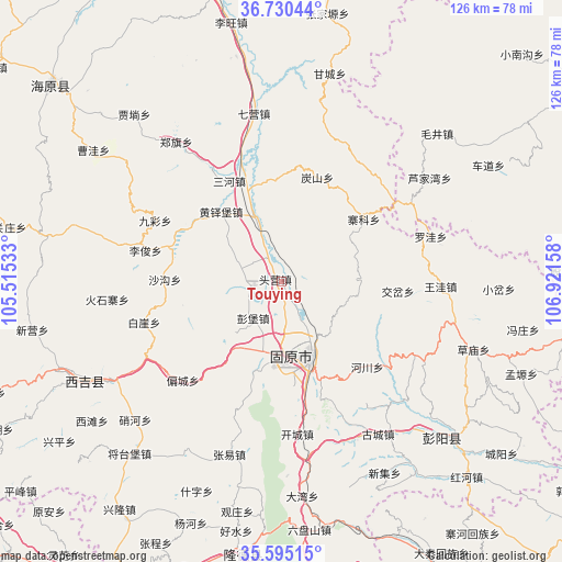
Touying GPS coordinates[2]
36° 9' 53.46" North, 106° 13' 6.42" East
| Map corner | latitude | longitude |
|---|---|---|
| Upper-left | 36.73044°, | 105.51533° |
| Center: | 36.16485°, | 106.21845° |
| Lower-right: | 35.59515°, | 106.92158° |
| Map W x H: | 126.2×126.2 km | = 78.4×78.4mi |
| max Lat: | 53.31946° ⇑22.4% North |
| Touying: | 36.16485° |
| min Lat: | ⇓77.6% South 18.22056° |
| min Long | Touying | max Long |
| 75.07348° | 106.21845° | 134.28917° |
| W 13.9%⇐ | ⇒86.1% E |
Elevation
Elevation of Touying is 1584 m = 5197 ft, and this is 1099.2 m = 3606 ft above average elevation for this country.
| Max E: |
5622 m = 18445 ft | 8% |
| Touying | 1584 m 5197 ft | |
| Avg. | 484.8 m = 1591 ft | |
Min E: |
-3 m = -10 ft | 92% |
See also: China elevation on elevation.city.
Geographical zone
Touying is located in North temperate zone (between Tropic of Cancer and the Arctic Circle). Distance of this Northern Tropic circle is 1415.2 km =879.4 mi to South.| Distance of | km | miles | from Touying |
|---|---|---|---|
| North Pole | 5985.9 | 3719.5 | to North |
| Arctic Circle | 3380 | 2100.2 | to North |
| Tropic Cancer | 1415.2 | 879.4 | to South |
| Equator | 4021.2 | 2498.7 | to South |


Nearby cities:
15 places around Touying: (largest is in red/bold)
• Chengjiao
18.8 km =11.7 mi,  158°
158°
• Dongjiao
18.9 km =11.7 mi, 160°
• Gongbailiang
24.8 km =15.4 mi,  18°
18°
• Gonghe
17 km =10.6 mi,  128°
128°
• Guanting
17.6 km =10.9 mi,  90°
90°
• Heiquan
7.2 km =4.5 mi,  203°
203°
• Huangduobu
20.9 km =13 mi,  319°
319°
• Pengbao
10.4 km =6.5 mi,  218°
218°
• Sanying
14.2 km =8.8 mi,  336°
336°
• Tanshan
24.9 km =15.5 mi, 18°
• Xijiao
18 km =11.2 mi, 163°
• Xinshan
25.5 km =15.8 mi,  34°
34°
• Yanglang
8.1 km =5 mi,  327°
327°
• Zhaike
23.2 km =14.4 mi,  52°
52°
• Zhonghe
15.2 km =9.4 mi, 195°
Sources, notices
• [Note1] Compared only with cities in China existing in our database
• [Src1] Map data: © OpenStreetMap contributors (CC-BY-SA)
• [Src2] Other city data from geonames.org with taken over terms of usage.
• [Src3] Geographical zone / Annual Mean Temperature by Robert A. Rohde @ Wikipedia
