Chaoyangchuan geodata
Chaoyangchuan (Jilin) is a seat of a fourth-order administrative division; located in China in Asia/Shanghai (GMT+8) time zone. In our database, there are 1268 cities with bigger population. Compared to other cities in China, 91.8% of cities are located further ↓South; 98.6% of cities are located further ←West and 54.5% of cities have lower elevation than Chaoyangchuan. Note1


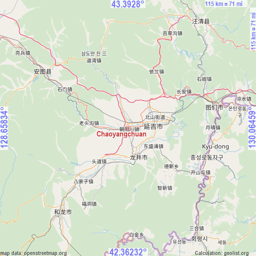
Chaoyangchuan GPS coordinates[2]
42° 52' 46.956" North, 129° 21' 41.256" East
| Map corner | latitude | longitude |
|---|---|---|
| Upper-left | 43.3928°, | 128.65834° |
| Center: | 42.87971°, | 129.36146° |
| Lower-right: | 42.36232°, | 130.06459° |
| Map W x H: | 114.6×114.6 km | = 71.2×71.2mi |
| max Lat: | 53.31946° ⇑8.2% North |
| Chaoyangchuan: | 42.87971° |
| min Lat: | ⇓91.8% South 18.22056° |
| min Long | Chaoyangchuan | max Long |
| 75.07348° | 129.36146° | 134.28917° |
| W 98.6%⇐ | ⇒1.4% E |
Elevation
Elevation of Chaoyangchuan is 201 m = 659 ft, and this is 283.8 m = 931 ft below average elevation for this country.
| Max E: |
5622 m = 18445 ft | 45.5% |
| Avg. | 484.8 m = 1591 ft | |
| Chaoyangchuan | 201 m = 659 ft | |
Min E: |
-3 m = -10 ft | 54.5% |
See also: China elevation on elevation.city.
Geographical zone
Chaoyangchuan is located in North temperate zone (between Tropic of Cancer and the Arctic Circle). Distance of this Northern Tropic circle is 2161.9 km =1343.3 mi to South.| Distance of | km | miles | from Chaoyangchuan |
|---|---|---|---|
| North Pole | 5239.3 | 3255.5 | to North |
| Arctic Circle | 2633.4 | 1636.3 | to North |
| Tropic Cancer | 2161.9 | 1343.3 | to South |
| Equator | 4767.8 | 2962.6 | to South |


Nearby cities:
15 places around Chaoyangchuan: (largest is in red/bold)
• Bajiazi
31.2 km =19.4 mi,  220°
220°
• Beixinjie
19.7 km =12.2 mi, 222°
• Chang’an
29.9 km =18.6 mi,  56°
56°
• Chongmin
25.7 km =16 mi,  130°
130°
• Dalazi
31.3 km =19.4 mi,  148°
148°
• Dongshengyong
13.8 km =8.6 mi,  124°
124°
• Erdao
29.8 km =18.5 mi,  227°
227°
• Jiulong
28.3 km =17.6 mi,  26°
26°
• Longjing
13.1 km =8.1 mi,  157°
157°
• Pucheng
15.4 km =9.6 mi,  191°
191°
• Shimen
32.8 km =20.4 mi,  301°
301°
• Tongfosi
9.7 km =6 mi,  275°
275°
• Xiaoying
13.5 km =8.4 mi,  74°
74°
• Xilinhe
17.3 km =10.7 mi,  253°
253°
• Yanji
12.3 km =7.6 mi,  75°
75°
Sources, notices
• [Note1] Compared only with cities in China existing in our database
• [Src1] Map data: © OpenStreetMap contributors (CC-BY-SA)
• [Src2] Other city data from geonames.org with taken over terms of usage.
• [Src3] Geographical zone / Annual Mean Temperature by Robert A. Rohde @ Wikipedia
