Longjing geodata
Longjing (Jilin) is a seat of a third-order administrative division; located in China in Asia/Shanghai (GMT+8) time zone. With population of 117,185 people, there are 371 cities with bigger population in this country. Compared to other cities in China, 91.7% of cities are located further ↓South; 98.7% of cities are located further ←West and 58.8% of cities have lower elevation than Longjing. Note1


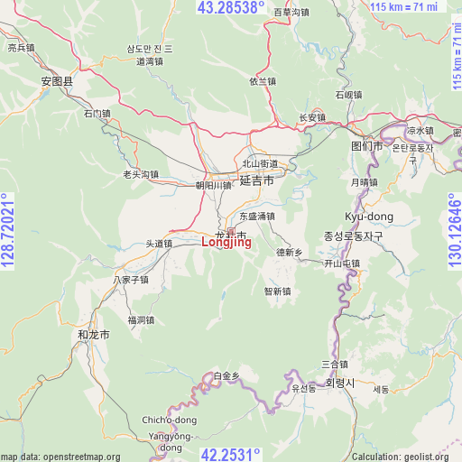
Longjing GPS coordinates[2]
42° 46' 17.004" North, 129° 25' 23.988" East
| Map corner | latitude | longitude |
|---|---|---|
| Upper-left | 43.28538°, | 128.72021° |
| Center: | 42.77139°, | 129.42333° |
| Lower-right: | 42.2531°, | 130.12646° |
| Map W x H: | 114.8×114.8 km | = 71.3×71.3mi |
| max Lat: | 53.31946° ⇑8.3% North |
| Longjing: | 42.77139° |
| min Lat: | ⇓91.7% South 18.22056° |
| min Long | Longjing | max Long |
| 75.07348° | 129.42333° | 134.28917° |
| W 98.7%⇐ | ⇒1.3% E |
Elevation
Elevation of Longjing is 245 m = 804 ft, and this is 239.8 m = 787 ft below average elevation for this country.
| Max E: |
5622 m = 18445 ft | 41.2% |
| Avg. | 484.8 m = 1591 ft | |
| Longjing | 245 m = 804 ft | |
Min E: |
-3 m = -10 ft | 58.8% |
See also: Longjing elevation on elevation.city.
Geographical zone
Longjing is located in North temperate zone (between Tropic of Cancer and the Arctic Circle). Distance of this Northern Tropic circle is 2149.8 km =1335.8 mi to South.| Distance of | km | miles | from Longjing |
|---|---|---|---|
| North Pole | 5251.3 | 3263 | to North |
| Arctic Circle | 2645.4 | 1643.8 | to North |
| Tropic Cancer | 2149.8 | 1335.8 | to South |
| Equator | 4755.7 | 2955.1 | to South |


Nearby cities:
15 places around Longjing: (largest is in red/bold)
• Bajiazi
27.9 km =17.3 mi,  245°
245°
• Beixinjie
18.5 km =11.5 mi,  262°
262°
• Chang’an
34.8 km =21.6 mi,  35°
35°
• Chaoyangchuan
13.1 km =8.1 mi,  337°
337°
• Chongmin
15.1 km =9.4 mi,  108°
108°
• Dalazi
18.5 km =11.5 mi,  142°
142°
• Dongshengyong
7.5 km =4.7 mi,  56°
56°
• Erdao
28.2 km =17.5 mi, 253°
• Fudong
31.4 km =19.5 mi,  225°
225°
• Kaishantun
28.4 km =17.6 mi, 105°
• Pucheng
8.6 km =5.3 mi, 249°
• Tongfosi
19.6 km =12.2 mi,  311°
311°
• Xiaoying
17.5 km =10.9 mi,  26°
26°
• Xilinhe
22.8 km =14.2 mi,  288°
288°
• Yanji
16.6 km =10.3 mi,  24°
24°
Sources, notices
• [Note1] Compared only with cities in China existing in our database
• [Src1] Map data: © OpenStreetMap contributors (CC-BY-SA)
• [Src2] Other city data from geonames.org with taken over terms of usage.
• [Src3] Geographical zone / Annual Mean Temperature by Robert A. Rohde @ Wikipedia
