Yaquehu geodata
Yaquehu (Jiangxi) is a seat of a fourth-order administrative division; located in China in Asia/Shanghai (GMT+8) time zone. In our database, there are 1268 cities with bigger population. Compared to other cities in China, 61.7% of cities are located further ↑North; 63.8% of cities are located further ←West and 83.9% of cities have higher elevation than Yaquehu. Note1


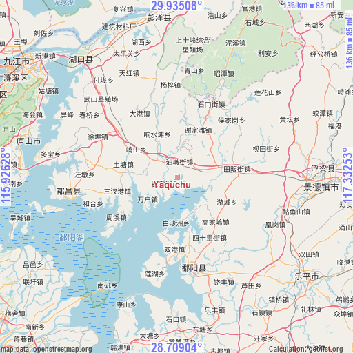
Yaquehu GPS coordinates[2]
29° 19' 26.04" North, 116° 37' 45.84" East
| Map corner | latitude | longitude |
|---|---|---|
| Upper-left | 29.93508°, | 115.92628° |
| Center: | 29.3239°, | 116.6294° |
| Lower-right: | 28.70904°, | 117.33253° |
| Map W x H: | 136.3×136.3 km | = 84.7×84.7mi |
| max Lat: | 53.31946° ⇑61.7% North |
| Yaquehu: | 29.3239° |
| min Lat: | ⇓38.3% South 18.22056° |
| min Long | Yaquehu | max Long |
| 75.07348° | 116.6294° | 134.28917° |
| W 63.8%⇐ | ⇒36.2% E |
Elevation
Elevation of Yaquehu is 18 m = 59 ft, and this is 466.8 m = 1531 ft below average elevation for this country.
| Max E: |
5622 m = 18445 ft | 83.9% |
| Avg. | 484.8 m = 1591 ft | |
| Yaquehu | 18 m = 59 ft | |
Min E: |
-3 m = -10 ft | 16.1% |
See also: China elevation on elevation.city.
Geographical zone
Yaquehu is located in North temperate zone (between Tropic of Cancer and the Arctic Circle). Distance of this Northern Tropic circle is 654.6 km =406.7 mi to South.| Distance of | km | miles | from Yaquehu |
|---|---|---|---|
| North Pole | 6746.5 | 4192.1 | to North |
| Arctic Circle | 4140.7 | 2572.9 | to North |
| Tropic Cancer | 654.6 | 406.7 | to South |
| Equator | 3260.5 | 2026 | to South |


Nearby cities:
15 places around Yaquehu: (largest is in red/bold)
• Baishazhou
18.3 km =11.4 mi,  184°
184°
• Mingshan
19.4 km =12.1 mi,  303°
303°
• Nanfeng
9.4 km =5.8 mi,  224°
224°
• Shishan
14.8 km =9.2 mi,  286°
286°
• Tutang
20.9 km =13 mi,  281°
281°
• Wanhu
14.3 km =8.9 mi,  231°
231°
• Xiangshuitang
18.5 km =11.5 mi,  335°
335°
• Xiangxi
12.1 km =7.5 mi, 220°
• Xiejiatan
19.9 km =12.4 mi,  23°
23°
• Yinbaohu
6.1 km =3.8 mi, 232°
• Youcheng
21.8 km =13.5 mi,  116°
116°
• Youdunjie
6 km =3.7 mi,  7°
7°
• Zhegang
10.1 km =6.3 mi,  76°
76°
• Zhongguan
11.5 km =7.1 mi,  305°
305°
• Zhuhu
15.8 km =9.8 mi,  165°
165°
Sources, notices
• [Note1] Compared only with cities in China existing in our database
• [Src1] Map data: © OpenStreetMap contributors (CC-BY-SA)
• [Src2] Other city data from geonames.org with taken over terms of usage.
• [Src3] Geographical zone / Annual Mean Temperature by Robert A. Rohde @ Wikipedia
