Wenwuba geodata
Wenwuba (Jiangxi) is a seat of a fourth-order administrative division; located in China in Asia/Shanghai (GMT+8) time zone. In our database, there are 1268 cities with bigger population. Compared to other cities in China, 83.8% of cities are located further ↑North; 58.8% of cities are located further ←West and 51% of cities have lower elevation than Wenwuba. Note1


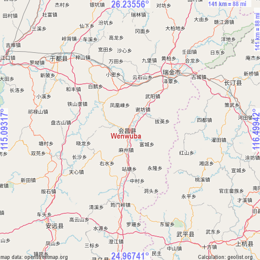
Wenwuba GPS coordinates[2]
25° 36' 11.412" North, 115° 47' 46.644" East
| Map corner | latitude | longitude |
|---|---|---|
| Upper-left | 26.23556°, | 115.09317° |
| Center: | 25.60317°, | 115.79629° |
| Lower-right: | 24.96741°, | 116.49942° |
| Map W x H: | 141×141 km | = 87.6×87.6mi |
| max Lat: | 53.31946° ⇑83.8% North |
| Wenwuba: | 25.60317° |
| min Lat: | ⇓16.2% South 18.22056° |
| min Long | Wenwuba | max Long |
| 75.07348° | 115.79629° | 134.28917° |
| W 58.8%⇐ | ⇒41.2% E |
Elevation
Elevation of Wenwuba is 173 m = 568 ft, and this is 311.8 m = 1023 ft below average elevation for this country.
| Max E: |
5622 m = 18445 ft | 49% |
| Avg. | 484.8 m = 1591 ft | |
| Wenwuba | 173 m = 568 ft | |
Min E: |
-3 m = -10 ft | 51% |
See also: China elevation on elevation.city.
Geographical zone
Wenwuba is located in North temperate zone (between Tropic of Cancer and the Arctic Circle). Distance of this Northern Tropic circle is 240.9 km =149.7 mi to South.| Distance of | km | miles | from Wenwuba |
|---|---|---|---|
| North Pole | 7160.3 | 4449.2 | to North |
| Arctic Circle | 4554.4 | 2830 | to North |
| Tropic Cancer | 240.9 | 149.7 | to South |
| Equator | 2846.8 | 1768.9 | to South |


Nearby cities:
15 places around Wenwuba: (largest is in red/bold)
• Baying
18 km =11.2 mi,  74°
74°
• Fenghuangdong
14.9 km =9.3 mi,  338°
338°
• Fucheng
11.8 km =7.3 mi,  129°
129°
• Gaopai
22.7 km =14.1 mi,  236°
236°
• Huichang
1.9 km =1.2 mi,  261°
261°
• Mazhou
10.7 km =6.6 mi,  191°
191°
• Wuyang
22.1 km =13.7 mi,  33°
33°
• Xiaolong
26.1 km =16.2 mi,  254°
254°
• Xiefang
13.4 km =8.3 mi, 31°
• Yonglong
24.7 km =15.3 mi,  146°
146°
• Youshui
21.8 km =13.5 mi,  215°
215°
• Zhantang
20.8 km =12.9 mi,  181°
181°
• Zhuangbu
22.9 km =14.2 mi,  297°
297°
• Zhuangkou
20.6 km =12.8 mi,  316°
316°
• Zhulan
8.9 km =5.5 mi,  287°
287°
Sources, notices
• [Note1] Compared only with cities in China existing in our database
• [Src1] Map data: © OpenStreetMap contributors (CC-BY-SA)
• [Src2] Other city data from geonames.org with taken over terms of usage.
• [Src3] Geographical zone / Annual Mean Temperature by Robert A. Rohde @ Wikipedia
