Fucheng geodata
Fucheng (Jiangxi) is a seat of a fourth-order administrative division; located in China in Asia/Shanghai (GMT+8) time zone. In our database, there are 1268 cities with bigger population. Compared to other cities in China, 84.1% of cities are located further ↑North; 59.4% of cities are located further ←West and 62.1% of cities have lower elevation than Fucheng. Note1


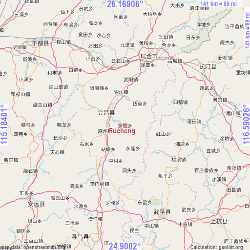
Fucheng GPS coordinates[2]
25° 32' 10.716" North, 115° 53' 13.668" East
| Map corner | latitude | longitude |
|---|---|---|
| Upper-left | 26.16906°, | 115.18401° |
| Center: | 25.53631°, | 115.88713° |
| Lower-right: | 24.9002°, | 116.59026° |
| Map W x H: | 141.1×141.1 km | = 87.7×87.7mi |
| max Lat: | 53.31946° ⇑84.1% North |
| Fucheng: | 25.53631° |
| min Lat: | ⇓15.9% South 18.22056° |
| min Long | Fucheng | max Long |
| 75.07348° | 115.88713° | 134.28917° |
| W 59.4%⇐ | ⇒40.6% E |
Elevation
Elevation of Fucheng is 284 m = 932 ft, and this is 200.8 m = 659 ft below average elevation for this country.
| Max E: |
5622 m = 18445 ft | 37.9% |
| Avg. | 484.8 m = 1591 ft | |
| Fucheng | 284 m = 932 ft | |
Min E: |
-3 m = -10 ft | 62.1% |
See also: China elevation on elevation.city.
Geographical zone
Fucheng is located in North temperate zone (between Tropic of Cancer and the Arctic Circle). Distance of this Northern Tropic circle is 233.5 km =145.1 mi to South.| Distance of | km | miles | from Fucheng |
|---|---|---|---|
| North Pole | 7167.7 | 4453.8 | to North |
| Arctic Circle | 4561.8 | 2834.6 | to North |
| Tropic Cancer | 233.5 | 145.1 | to South |
| Equator | 2839.4 | 1764.3 | to South |


Nearby cities:
15 places around Fucheng: (largest is in red/bold)
• Baying
14.8 km =9.2 mi,  33°
33°
• Dahe
26.3 km =16.3 mi,  125°
125°
• Dongtou
25.6 km =15.9 mi,  174°
174°
• Fenghuangdong
25.8 km =16 mi,  325°
325°
• Hongshan
22.1 km =13.7 mi,  101°
101°
• Huichang
13.1 km =8.1 mi,  303°
303°
• Mazhou
11.6 km =7.2 mi,  254°
254°
• Wenwuba
11.8 km =7.3 mi,  309°
309°
• Wuyang
26 km =16.2 mi,  6°
6°
• Xiefang
19.1 km =11.9 mi,  353°
353°
• Yonglong
13.9 km =8.6 mi,  161°
161°
• Youshui
24.1 km =15 mi,  244°
244°
• Zhantang
16.4 km =10.2 mi,  215°
215°
• Zhongcun
20.5 km =12.7 mi,  194°
194°
• Zhulan
20.3 km =12.6 mi, 299°
Sources, notices
• [Note1] Compared only with cities in China existing in our database
• [Src1] Map data: © OpenStreetMap contributors (CC-BY-SA)
• [Src2] Other city data from geonames.org with taken over terms of usage.
• [Src3] Geographical zone / Annual Mean Temperature by Robert A. Rohde @ Wikipedia
