Chigu geodata
Chigu (Jiangxi) is a seat of a fourth-order administrative division; located in China in Asia/Shanghai (GMT+8) time zone. In our database, there are 1268 cities with bigger population. Compared to other cities in China, 76.4% of cities are located further ↑North; 52.4% of cities are located further ←West and 55.1% of cities have higher elevation than Chigu. Note1


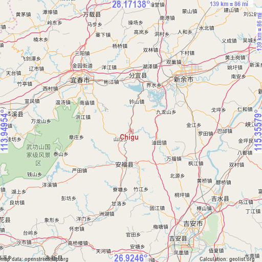
Chigu GPS coordinates[2]
27° 32' 59.136" North, 114° 39' 9.576" East
| Map corner | latitude | longitude |
|---|---|---|
| Upper-left | 28.17138°, | 113.94954° |
| Center: | 27.54976°, | 114.65266° |
| Lower-right: | 26.9246°, | 115.35579° |
| Map W x H: | 138.6×138.6 km | = 86.1×86.1mi |
| max Lat: | 53.31946° ⇑76.4% North |
| Chigu: | 27.54976° |
| min Lat: | ⇓23.6% South 18.22056° |
| min Long | Chigu | max Long |
| 75.07348° | 114.65266° | 134.28917° |
| W 52.4%⇐ | ⇒47.6% E |
Elevation
Elevation of Chigu is 131 m = 430 ft, and this is 353.8 m = 1161 ft below average elevation for this country.
| Max E: |
5622 m = 18445 ft | 55.1% |
| Avg. | 484.8 m = 1591 ft | |
| Chigu | 131 m = 430 ft | |
Min E: |
-3 m = -10 ft | 44.9% |
See also: China elevation on elevation.city.
Geographical zone
Chigu is located in North temperate zone (between Tropic of Cancer and the Arctic Circle). Distance of this Northern Tropic circle is 457.3 km =284.2 mi to South.| Distance of | km | miles | from Chigu |
|---|---|---|---|
| North Pole | 6943.8 | 4314.7 | to North |
| Arctic Circle | 4337.9 | 2695.4 | to North |
| Tropic Cancer | 457.3 | 284.2 | to South |
| Equator | 3063.2 | 1903.4 | to South |


Nearby cities:
15 places around Chigu: (largest is in red/bold)
• Binjiang
27.9 km =17.3 mi,  339°
339°
• Dagangshan
13.4 km =8.3 mi,  331°
331°
• Fengtian
20.4 km =12.7 mi,  167°
167°
• Guashe
16.6 km =10.3 mi,  156°
156°
• Henglong
20.3 km =12.6 mi,  209°
209°
• Hongjiang
26.8 km =16.7 mi,  287°
287°
• Jiulongshan
21.2 km =13.2 mi,  60°
60°
• Pingdu
18.7 km =11.6 mi,  192°
192°
• Shanzhuang
6.6 km =4.1 mi,  235°
235°
• Songshan
9.2 km =5.7 mi,  4°
4°
• Wanfu
27.4 km =17 mi,  124°
124°
• Xinfang
24.6 km =15.3 mi,  312°
312°
• Xinzhi
16.4 km =10.2 mi,  10°
10°
• Youtian
14.4 km =8.9 mi,  106°
106°
• Yuankeng
13.3 km =8.3 mi,  33°
33°
Sources, notices
• [Note1] Compared only with cities in China existing in our database
• [Src1] Map data: © OpenStreetMap contributors (CC-BY-SA)
• [Src2] Other city data from geonames.org with taken over terms of usage.
• [Src3] Geographical zone / Annual Mean Temperature by Robert A. Rohde @ Wikipedia
