Lingdong geodata
Lingdong (Jiangxi) is a seat of a fourth-order administrative division; located in China in Asia/Shanghai (GMT+8) time zone. In our database, there are 1268 cities with bigger population. Compared to other cities in China, 73.6% of cities are located further ↑North; 50.1% of cities are located further ←West and 51.6% of cities have lower elevation than Lingdong. Note1


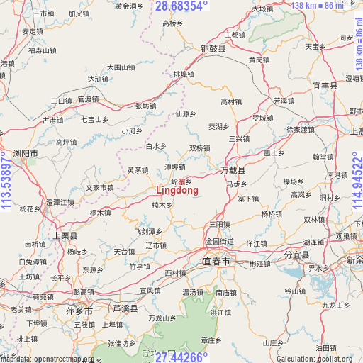
Lingdong GPS coordinates[2]
28° 3' 53.604" North, 114° 14' 31.524" East
| Map corner | latitude | longitude |
|---|---|---|
| Upper-left | 28.68354°, | 113.53897° |
| Center: | 28.06489°, | 114.24209° |
| Lower-right: | 27.44266°, | 114.94522° |
| Map W x H: | 138×138 km | = 85.7×85.7mi |
| max Lat: | 53.31946° ⇑73.6% North |
| Lingdong: | 28.06489° |
| min Lat: | ⇓26.4% South 18.22056° |
| min Long | Lingdong | max Long |
| 75.07348° | 114.24209° | 134.28917° |
| W 50.1%⇐ | ⇒49.9% E |
Elevation
Elevation of Lingdong is 178 m = 584 ft, and this is 306.8 m = 1007 ft below average elevation for this country.
| Max E: |
5622 m = 18445 ft | 48.4% |
| Avg. | 484.8 m = 1591 ft | |
| Lingdong | 178 m = 584 ft | |
Min E: |
-3 m = -10 ft | 51.6% |
See also: China elevation on elevation.city.
Geographical zone
Lingdong is located in North temperate zone (between Tropic of Cancer and the Arctic Circle). Distance of this Northern Tropic circle is 514.6 km =319.8 mi to South.| Distance of | km | miles | from Lingdong |
|---|---|---|---|
| North Pole | 6886.5 | 4279.1 | to North |
| Arctic Circle | 4280.7 | 2659.9 | to North |
| Tropic Cancer | 514.6 | 319.8 | to South |
| Equator | 3120.5 | 1939 | to South |


Nearby cities:
15 places around Lingdong: (largest is in red/bold)
• Baimu
19.9 km =12.4 mi,  110°
110°
• Baishui
17 km =10.6 mi,  324°
324°
• Chixing
16.2 km =10.1 mi,  358°
358°
• Efeng
21.3 km =13.2 mi,  75°
75°
• Fengdingshan
7.3 km =4.5 mi,  145°
145°
• Gaocheng
11.3 km =7 mi,  68°
68°
• Hongtang
18.4 km =11.4 mi,  165°
165°
• Huangmao
17.3 km =10.7 mi,  285°
285°
• Jinrui
15.9 km =9.9 mi,  194°
194°
• Kangle
20.7 km =12.9 mi, 80°
• Mabu
19.6 km =12.2 mi, 78°
• Nanmu
11.4 km =7.1 mi,  220°
220°
• Shuangqiao
14.9 km =9.3 mi,  27°
27°
• Tanbu
6.3 km =3.9 mi,  335°
335°
• Zhutan
8.1 km =5 mi,  260°
260°
Sources, notices
• [Note1] Compared only with cities in China existing in our database
• [Src1] Map data: © OpenStreetMap contributors (CC-BY-SA)
• [Src2] Other city data from geonames.org with taken over terms of usage.
• [Src3] Geographical zone / Annual Mean Temperature by Robert A. Rohde @ Wikipedia
