Zhutan geodata
Zhutan (Jiangxi) is a seat of a fourth-order administrative division; located in China in Asia/Shanghai (GMT+8) time zone. In our database, there are 1268 cities with bigger population. Compared to other cities in China, 73.6% of cities are located further ↑North; 50.3% of cities are located further →East and 53.7% of cities have higher elevation than Zhutan. Note1


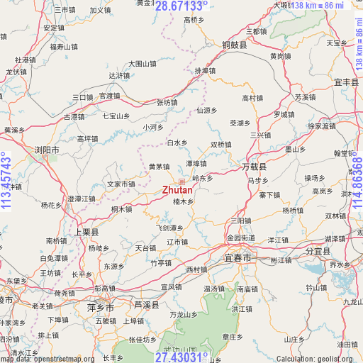
Zhutan GPS coordinates[2]
28° 3' 9.396" North, 114° 9' 37.98" East
| Map corner | latitude | longitude |
|---|---|---|
| Upper-left | 28.67133°, | 113.45743° |
| Center: | 28.05261°, | 114.16055° |
| Lower-right: | 27.43031°, | 114.86368° |
| Map W x H: | 138×138 km | = 85.7×85.7mi |
| max Lat: | 53.31946° ⇑73.6% North |
| Zhutan: | 28.05261° |
| min Lat: | ⇓26.4% South 18.22056° |
| min Long | Zhutan | max Long |
| 75.07348° | 114.16055° | 134.28917° |
| W 49.7%⇐ | ⇒50.3% E |
Elevation
Elevation of Zhutan is 139 m = 456 ft, and this is 345.8 m = 1135 ft below average elevation for this country.
| Max E: |
5622 m = 18445 ft | 53.7% |
| Avg. | 484.8 m = 1591 ft | |
| Zhutan | 139 m = 456 ft | |
Min E: |
-3 m = -10 ft | 46.3% |
See also: China elevation on elevation.city.
Geographical zone
Zhutan is located in North temperate zone (between Tropic of Cancer and the Arctic Circle). Distance of this Northern Tropic circle is 513.2 km =318.9 mi to South.| Distance of | km | miles | from Zhutan |
|---|---|---|---|
| North Pole | 6887.9 | 4279.9 | to North |
| Arctic Circle | 4282 | 2660.7 | to North |
| Tropic Cancer | 513.2 | 318.9 | to South |
| Equator | 3119.2 | 1938.2 | to South |


Nearby cities:
15 places around Zhutan: (largest is in red/bold)
• Baishui
15.4 km =9.6 mi,  352°
352°
• Chixing
19.1 km =11.9 mi,  23°
23°
• Cihua
13.8 km =8.6 mi,  251°
251°
• Feijiantan
17.9 km =11.1 mi,  194°
194°
• Fengdingshan
13 km =8.1 mi,  110°
110°
• Gaocheng
19.3 km =12 mi,  73°
73°
• Heshikou
21.4 km =13.3 mi,  332°
332°
• Hongtang
20.7 km =12.9 mi,  142°
142°
• Huangmao
10.6 km =6.6 mi,  305°
305°
• Jinrui
14.6 km =9.1 mi,  163°
163°
• Lingdong
8.1 km =5 mi,  80°
80°
• Nanmu
7.2 km =4.5 mi,  175°
175°
• Raoshi
22.6 km =14 mi, 184°
• Shuangqiao
20.8 km =12.9 mi,  45°
45°
• Tanbu
8.9 km =5.5 mi,  37°
37°
Sources, notices
• [Note1] Compared only with cities in China existing in our database
• [Src1] Map data: © OpenStreetMap contributors (CC-BY-SA)
• [Src2] Other city data from geonames.org with taken over terms of usage.
• [Src3] Geographical zone / Annual Mean Temperature by Robert A. Rohde @ Wikipedia
