Caochang geodata
Caochang (Jiangxi) is a seat of a fourth-order administrative division; located in China in Asia/Shanghai (GMT+8) time zone. In our database, there are 1268 cities with bigger population. Compared to other cities in China, 73.5% of cities are located further ↑North; 52.4% of cities are located further ←West and 57.7% of cities have higher elevation than Caochang. Note1


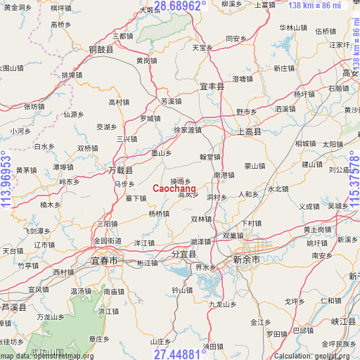
Caochang GPS coordinates[2]
28° 4' 15.636" North, 114° 40' 21.54" East
| Map corner | latitude | longitude |
|---|---|---|
| Upper-left | 28.68962°, | 113.96953° |
| Center: | 28.07101°, | 114.67265° |
| Lower-right: | 27.44881°, | 115.37578° |
| Map W x H: | 138×138 km | = 85.7×85.7mi |
| max Lat: | 53.31946° ⇑73.5% North |
| Caochang: | 28.07101° |
| min Lat: | ⇓26.5% South 18.22056° |
| min Long | Caochang | max Long |
| 75.07348° | 114.67265° | 134.28917° |
| W 52.4%⇐ | ⇒47.6% E |
Elevation
Elevation of Caochang is 113 m = 371 ft, and this is 371.8 m = 1220 ft below average elevation for this country.
| Max E: |
5622 m = 18445 ft | 57.7% |
| Avg. | 484.8 m = 1591 ft | |
| Caochang | 113 m = 371 ft | |
Min E: |
-3 m = -10 ft | 42.3% |
See also: China elevation on elevation.city.
Geographical zone
Caochang is located in North temperate zone (between Tropic of Cancer and the Arctic Circle). Distance of this Northern Tropic circle is 515.3 km =320.2 mi to South.| Distance of | km | miles | from Caochang |
|---|---|---|---|
| North Pole | 6885.9 | 4278.7 | to North |
| Arctic Circle | 4280 | 2659.5 | to North |
| Tropic Cancer | 515.3 | 320.2 | to South |
| Equator | 3121.2 | 1939.4 | to South |


Nearby cities:
15 places around Caochang: (largest is in red/bold)
• Damiao
20.8 km =12.9 mi,  88°
88°
• Dongcun
15.3 km =9.5 mi,  114°
114°
• Efeng
22.1 km =13.7 mi,  281°
281°
• Gaolan
6.1 km =3.8 mi,  147°
147°
• Hantang
14.6 km =9.1 mi,  51°
51°
• Kangle
22 km =13.7 mi, 277°
• Luzhou
22.2 km =13.8 mi, 46°
• Nangang
16.8 km =10.4 mi,  82°
82°
• Shuanglin
16.7 km =10.4 mi, 150°
• Siquanpu
12.8 km =8 mi,  326°
326°
• Tianxin
9.9 km =6.2 mi,  316°
316°
• Xujiadu
19.7 km =12.2 mi,  8°
8°
• Yangqiao
15 km =9.3 mi,  212°
212°
• Zhaixia
18.5 km =11.5 mi,  248°
248°
• Zhendu
16.4 km =10.2 mi, 334°
Sources, notices
• [Note1] Compared only with cities in China existing in our database
• [Src1] Map data: © OpenStreetMap contributors (CC-BY-SA)
• [Src2] Other city data from geonames.org with taken over terms of usage.
• [Src3] Geographical zone / Annual Mean Temperature by Robert A. Rohde @ Wikipedia
