Huangjiabu geodata
Huangjiabu (Zhejiang) is a seat of a fourth-order administrative division; located in China in Asia/Shanghai (GMT+8) time zone. In our database, there are 1268 cities with bigger population. Compared to other cities in China, 52.6% of cities are located further ↑North; 87.6% of cities are located further ←West and 94.3% of cities have higher elevation than Huangjiabu. Note1


Huangjiabu GPS coordinates[2]
30° 8' 36.924" North, 120° 57' 20.376" East
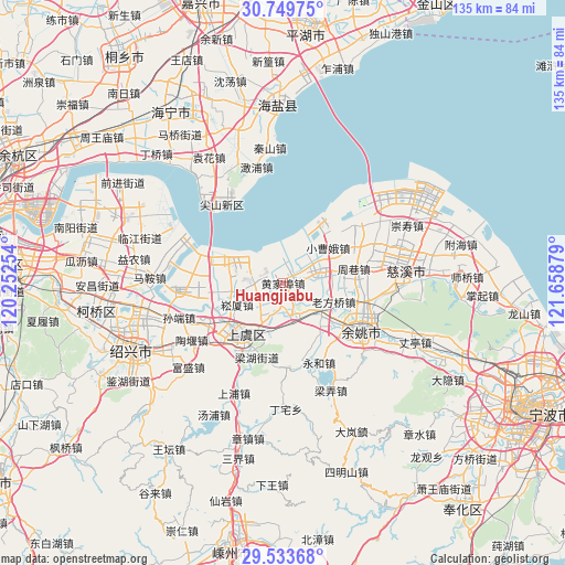
| Map corner | latitude | longitude |
|---|---|---|
| Upper-left | 30.74975°, | 120.25254° |
| Center: | 30.14359°, | 120.95566° |
| Lower-right: | 29.53368°, | 121.65879° |
| Map W x H: | 135.2×135.2 km | = 84×84mi |
| max Lat: | 53.31946° ⇑52.6% North |
| Huangjiabu: | 30.14359° |
| min Lat: | ⇓47.4% South 18.22056° |
| min Long | Huangjiabu | max Long |
| 75.07348° | 120.95566° | 134.28917° |
| W 87.6%⇐ | ⇒12.4% E |
Elevation
Elevation of Huangjiabu is 7 m = 23 ft, and this is 477.8 m = 1568 ft below average elevation for this country.
| Max E: |
5622 m = 18445 ft | 94.3% |
| Avg. | 484.8 m = 1591 ft | |
| Huangjiabu | 7 m = 23 ft | |
Min E: |
-3 m = -10 ft | 5.7% |
See also: China elevation on elevation.city.
Geographical zone
Huangjiabu is located in North temperate zone (between Tropic of Cancer and the Arctic Circle). Distance of this Northern Tropic circle is 745.7 km =463.4 mi to South.| Distance of | km | miles | from Huangjiabu |
|---|---|---|---|
| North Pole | 6655.4 | 4135.5 | to North |
| Arctic Circle | 4049.5 | 2516.2 | to North |
| Tropic Cancer | 745.7 | 463.4 | to South |
| Equator | 3351.7 | 2082.6 | to South |


Nearby cities:
15 places around Huangjiabu: (largest is in red/bold)
• Gaibei
6.5 km =4 mi,  266°
266°
• Langxia
11.8 km =7.3 mi,  76°
76°
• Lianghu
17.8 km =11.1 mi,  198°
198°
• Lihai
19.2 km =11.9 mi,  262°
262°
• Linshan
3.7 km =2.3 mi,  71°
71°
• Mazhu
11.4 km =7.1 mi,  129°
129°
• Moushan
8.3 km =5.2 mi,  156°
156°
• Shangyu
16.4 km =10.2 mi,  209°
209°
• Simen
8.3 km =5.2 mi, 75°
• Songxia
12.1 km =7.5 mi,  245°
245°
• Xiaodong
18.5 km =11.5 mi, 131°
• Xiaoyue
8.5 km =5.3 mi, 198°
• Xietang
5.8 km =3.6 mi, 245°
• Yangjialusanqiu
13.7 km =8.5 mi,  51°
51°
• Zhouxiang
16.9 km =10.5 mi, 78°
Sources, notices
• [Note1] Compared only with cities in China existing in our database
• [Src1] Map data: © OpenStreetMap contributors (CC-BY-SA)
• [Src2] Other city data from geonames.org with taken over terms of usage.
• [Src3] Geographical zone / Annual Mean Temperature by Robert A. Rohde @ Wikipedia
