Tianxing geodata
Tianxing (Hubei) is a seat of a fourth-order administrative division; located in China in Asia/Shanghai (GMT+8) time zone. In our database, there are 1268 cities with bigger population. Compared to other cities in China, 51.8% of cities are located further ↓South; 51.1% of cities are located further ←West and 84.9% of cities have higher elevation than Tianxing. Note1


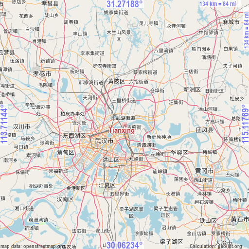
Tianxing GPS coordinates[2]
30° 40' 8.4" North, 114° 24' 52.416" East
| Map corner | latitude | longitude |
|---|---|---|
| Upper-left | 31.27188°, | 113.71144° |
| Center: | 30.669°, | 114.41456° |
| Lower-right: | 30.06234°, | 115.11769° |
| Map W x H: | 134.5×134.5 km | = 83.6×83.6mi |
| max Lat: | 53.31946° ⇑48.2% North |
| Tianxing: | 30.669° |
| min Lat: | ⇓51.8% South 18.22056° |
| min Long | Tianxing | max Long |
| 75.07348° | 114.41456° | 134.28917° |
| W 51.1%⇐ | ⇒48.9% E |
Elevation
Elevation of Tianxing is 16 m = 52 ft, and this is 468.8 m = 1538 ft below average elevation for this country.
| Max E: |
5622 m = 18445 ft | 84.9% |
| Avg. | 484.8 m = 1591 ft | |
| Tianxing | 16 m = 52 ft | |
Min E: |
-3 m = -10 ft | 15.1% |
See also: China elevation on elevation.city.
Geographical zone
Tianxing is located in North temperate zone (between Tropic of Cancer and the Arctic Circle). Distance of this Northern Tropic circle is 804.2 km =499.7 mi to South.| Distance of | km | miles | from Tianxing |
|---|---|---|---|
| North Pole | 6597 | 4099.2 | to North |
| Arctic Circle | 3991.1 | 2480 | to North |
| Tropic Cancer | 804.2 | 499.7 | to South |
| Equator | 3410.1 | 2118.9 | to South |


Nearby cities:
15 places around Tianxing: (largest is in red/bold)
• Baiyushan
10 km =6.2 mi,  135°
135°
• Dujiajing
4.1 km =2.5 mi,  100°
100°
• Guanshan
18.1 km =11.2 mi,  183°
183°
• Guanshang
13.3 km =8.3 mi, 95°
• Heping
5.1 km =3.2 mi,  209°
209°
• Hongqi
7.2 km =4.5 mi,  166°
166°
• Houhu
8.6 km =5.3 mi,  263°
263°
• Huashan
17 km =10.6 mi,  145°
145°
• Jiang’an Qu
12.3 km =7.6 mi,  237°
237°
• Jiaomingsi
12.7 km =7.9 mi,  358°
358°
• Shekou
8 km =5 mi,  308°
308°
• Wudong
10.4 km =6.5 mi,  158°
158°
• Wuhan
17.1 km =10.6 mi, 236°
• Wutongkou
2.8 km =1.7 mi,  338°
338°
• Zhanjiaji
6 km =3.7 mi,  270°
270°
Sources, notices
• [Note1] Compared only with cities in China existing in our database
• [Src1] Map data: © OpenStreetMap contributors (CC-BY-SA)
• [Src2] Other city data from geonames.org with taken over terms of usage.
• [Src3] Geographical zone / Annual Mean Temperature by Robert A. Rohde @ Wikipedia
