Heping geodata
Heping (Hubei) is a seat of a fourth-order administrative division; located in China in Asia/Shanghai (GMT+8) time zone. In our database, there are 1268 cities with bigger population. Compared to other cities in China, 51.4% of cities are located further ↓South; 50.9% of cities are located further ←West and 79.8% of cities have higher elevation than Heping. Note1


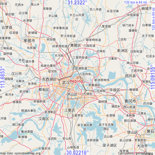
Heping GPS coordinates[2]
30° 37' 44.652" North, 114° 23' 18.312" East
| Map corner | latitude | longitude |
|---|---|---|
| Upper-left | 31.2322°, | 113.6853° |
| Center: | 30.62907°, | 114.38842° |
| Lower-right: | 30.02216°, | 115.09155° |
| Map W x H: | 134.5×134.5 km | = 83.6×83.6mi |
| max Lat: | 53.31946° ⇑48.6% North |
| Heping: | 30.62907° |
| min Lat: | ⇓51.4% South 18.22056° |
| min Long | Heping | max Long |
| 75.07348° | 114.38842° | 134.28917° |
| W 50.9%⇐ | ⇒49.1% E |
Elevation
Elevation of Heping is 27 m = 89 ft, and this is 457.8 m = 1502 ft below average elevation for this country.
| Max E: |
5622 m = 18445 ft | 79.8% |
| Avg. | 484.8 m = 1591 ft | |
| Heping | 27 m = 89 ft | |
Min E: |
-3 m = -10 ft | 20.2% |
See also: China elevation on elevation.city.
Geographical zone
Heping is located in North temperate zone (between Tropic of Cancer and the Arctic Circle). Distance of this Northern Tropic circle is 799.7 km =496.9 mi to South.| Distance of | km | miles | from Heping |
|---|---|---|---|
| North Pole | 6601.4 | 4101.9 | to North |
| Arctic Circle | 3995.5 | 2482.7 | to North |
| Tropic Cancer | 799.7 | 496.9 | to South |
| Equator | 3405.6 | 2116.1 | to South |


Nearby cities:
15 places around Heping: (largest is in red/bold)
• Baiyushan
9.9 km =6.2 mi,  105°
105°
• Dujiajing
7.5 km =4.7 mi,  60°
60°
• Guanshan
13.7 km =8.5 mi,  173°
173°
• Guanshang
16.1 km =10 mi,  78°
78°
• Hongqi
4.9 km =3 mi,  121°
121°
• Houhu
6.9 km =4.3 mi,  299°
299°
• Huashan
15.4 km =9.6 mi,  128°
128°
• Jiang’an Qu
8.1 km =5 mi,  253°
253°
• Shekou
10.1 km =6.3 mi,  338°
338°
• Tianxing
5.1 km =3.2 mi,  29°
29°
• Wangdian
15.9 km =9.9 mi,  147°
147°
• Wudong
8.2 km =5.1 mi, 129°
• Wuhan
12.7 km =7.9 mi, 246°
• Wutongkou
7.2 km =4.5 mi,  11°
11°
• Zhanjiaji
5.7 km =3.5 mi,  321°
321°
Sources, notices
• [Note1] Compared only with cities in China existing in our database
• [Src1] Map data: © OpenStreetMap contributors (CC-BY-SA)
• [Src2] Other city data from geonames.org with taken over terms of usage.
• [Src3] Geographical zone / Annual Mean Temperature by Robert A. Rohde @ Wikipedia
