Guanshan geodata
Guanshan (Hubei) is a seat of a fourth-order administrative division; located in China in Asia/Shanghai (GMT+8) time zone. In our database, there are 1268 cities with bigger population. Compared to other cities in China, 50.4% of cities are located further ↓South; 51% of cities are located further ←West and 77.2% of cities have higher elevation than Guanshan. Note1


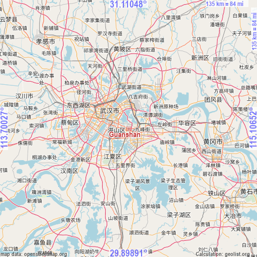
Guanshan GPS coordinates[2]
30° 30' 23.688" North, 114° 24' 12.204" East
| Map corner | latitude | longitude |
|---|---|---|
| Upper-left | 31.11048°, | 113.70027° |
| Center: | 30.50658°, | 114.40339° |
| Lower-right: | 29.89891°, | 115.10652° |
| Map W x H: | 134.7×134.7 km | = 83.7×83.7mi |
| max Lat: | 53.31946° ⇑49.6% North |
| Guanshan: | 30.50658° |
| min Lat: | ⇓50.4% South 18.22056° |
| min Long | Guanshan | max Long |
| 75.07348° | 114.40339° | 134.28917° |
| W 51%⇐ | ⇒49% E |
Elevation
Elevation of Guanshan is 32 m = 105 ft, and this is 452.8 m = 1486 ft below average elevation for this country.
| Max E: |
5622 m = 18445 ft | 77.2% |
| Avg. | 484.8 m = 1591 ft | |
| Guanshan | 32 m = 105 ft | |
Min E: |
-3 m = -10 ft | 22.8% |
See also: China elevation on elevation.city.
Geographical zone
Guanshan is located in North temperate zone (between Tropic of Cancer and the Arctic Circle). Distance of this Northern Tropic circle is 786.1 km =488.5 mi to South.| Distance of | km | miles | from Guanshan |
|---|---|---|---|
| North Pole | 6615 | 4110.4 | to North |
| Arctic Circle | 4009.2 | 2491.2 | to North |
| Tropic Cancer | 786.1 | 488.5 | to South |
| Equator | 3392 | 2107.7 | to South |


Nearby cities:
15 places around Guanshan: (largest is in red/bold)
• Baiyushan
13.6 km =8.5 mi,  36°
36°
• Dujiajing
18 km =11.2 mi,  16°
16°
• Heping
13.7 km =8.5 mi,  353°
353°
• Hongqi
11.4 km =7.1 mi,  13°
13°
• Huashan
11.3 km =7 mi,  69°
69°
• Jiangti
16 km =9.9 mi,  276°
276°
• Jiang’an Qu
14.7 km =9.1 mi,  320°
320°
• Liufang
8.1 km =5 mi,  147°
147°
• Shizishan
7.5 km =4.7 mi,  251°
251°
• Tianxing
18.1 km =11.2 mi,  3°
3°
• Wangdian
7.1 km =4.4 mi,  88°
88°
• Wudong
9.7 km =6 mi,  30°
30°
• Wuhan
15.6 km =9.7 mi,  303°
303°
• Wulijie
18.6 km =11.6 mi,  183°
183°
• Zhangjiawan
13 km =8.1 mi,  256°
256°
Sources, notices
• [Note1] Compared only with cities in China existing in our database
• [Src1] Map data: © OpenStreetMap contributors (CC-BY-SA)
• [Src2] Other city data from geonames.org with taken over terms of usage.
• [Src3] Geographical zone / Annual Mean Temperature by Robert A. Rohde @ Wikipedia
