Wuhan geodata
Wuhan (Hubei) is a seat of a first-order administrative division; located in China in Asia/Shanghai (GMT+8) time zone. With population of 9,785,388 people, there are 5 cities with bigger population in this country. Compared to other cities in China, 51% of cities are located further ↓South; 50.2% of cities are located further ←West and 82.9% of cities have higher elevation than Wuhan. Note1


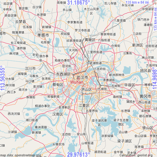
Wuhan GPS coordinates[2]
30° 34' 59.988" North, 114° 16' 0.012" East
| Map corner | latitude | longitude |
|---|---|---|
| Upper-left | 31.18675°, | 113.56355° |
| Center: | 30.58333°, | 114.26667° |
| Lower-right: | 29.97613°, | 114.9698° |
| Map W x H: | 134.6×134.6 km | = 83.6×83.6mi |
| max Lat: | 53.31946° ⇑49% North |
| Wuhan: | 30.58333° |
| min Lat: | ⇓51% South 18.22056° |
| min Long | Wuhan | max Long |
| 75.07348° | 114.26667° | 134.28917° |
| W 50.2%⇐ | ⇒49.8% E |
Elevation
Elevation of Wuhan is 20 m = 66 ft, and this is 464.8 m = 1525 ft below average elevation for this country.
| Max E: |
5622 m = 18445 ft | 82.9% |
| Avg. | 484.8 m = 1591 ft | |
| Wuhan | 20 m = 66 ft | |
Min E: |
-3 m = -10 ft | 17.1% |
See also: Wuhan elevation on elevation.city.
Geographical zone
Wuhan is located in North temperate zone (between Tropic of Cancer and the Arctic Circle). Distance of this Northern Tropic circle is 794.6 km =493.7 mi to South.| Distance of | km | miles | from Wuhan |
|---|---|---|---|
| North Pole | 6606.5 | 4105.1 | to North |
| Arctic Circle | 4000.6 | 2485.9 | to North |
| Tropic Cancer | 794.6 | 493.7 | to South |
| Equator | 3400.5 | 2113 | to South |


Nearby cities:
15 places around Wuhan: (largest is in red/bold)
• Changfeng
6.2 km =3.9 mi,  294°
294°
• Changqing
14.7 km =9.1 mi,  283°
283°
• Guanshan
15.6 km =9.7 mi,  123°
123°
• Heping
12.7 km =7.9 mi,  66°
66°
• Houhu
10.2 km =6.3 mi,  33°
33°
• Jiangti
7.2 km =4.5 mi,  202°
202°
• Jiang’an Qu
4.8 km =3 mi,  53°
53°
• Mintian
15.1 km =9.4 mi,  317°
317°
• Sandian
13.3 km =8.3 mi,  304°
304°
• Shilipu
5.6 km =3.5 mi,  244°
244°
• Shizishan
12.4 km =7.7 mi,  151°
151°
• Wujiashan
13.5 km =8.4 mi, 286°
• Yongfeng
4.9 km =3 mi,  245°
245°
• Zhangjiawan
11.7 km =7.3 mi,  177°
177°
• Zhanjiaji
12.5 km =7.8 mi,  40°
40°
Sources, notices
• [Note1] Compared only with cities in China existing in our database
• [Src1] Map data: © OpenStreetMap contributors (CC-BY-SA)
• [Src2] Other city data from geonames.org with taken over terms of usage.
• [Src3] Geographical zone / Annual Mean Temperature by Robert A. Rohde @ Wikipedia
