Shilipu geodata
Shilipu (Hubei) is a seat of a fourth-order administrative division; located in China in Asia/Shanghai (GMT+8) time zone. In our database, there are 1268 cities with bigger population. Compared to other cities in China, 50.8% of cities are located further ↓South; 50.1% of cities are located further →East and 77.2% of cities have higher elevation than Shilipu. Note1


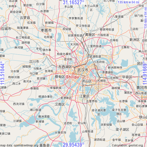
Shilipu GPS coordinates[2]
30° 33' 42.192" North, 114° 12' 48.816" East
| Map corner | latitude | longitude |
|---|---|---|
| Upper-left | 31.16527°, | 113.51044° |
| Center: | 30.56172°, | 114.21356° |
| Lower-right: | 29.95439°, | 114.91669° |
| Map W x H: | 134.6×134.6 km | = 83.6×83.6mi |
| max Lat: | 53.31946° ⇑49.2% North |
| Shilipu: | 30.56172° |
| min Lat: | ⇓50.8% South 18.22056° |
| min Long | Shilipu | max Long |
| 75.07348° | 114.21356° | 134.28917° |
| W 49.9%⇐ | ⇒50.1% E |
Elevation
Elevation of Shilipu is 32 m = 105 ft, and this is 452.8 m = 1486 ft below average elevation for this country.
| Max E: |
5622 m = 18445 ft | 77.2% |
| Avg. | 484.8 m = 1591 ft | |
| Shilipu | 32 m = 105 ft | |
Min E: |
-3 m = -10 ft | 22.8% |
See also: China elevation on elevation.city.
Geographical zone
Shilipu is located in North temperate zone (between Tropic of Cancer and the Arctic Circle). Distance of this Northern Tropic circle is 792.2 km =492.3 mi to South.| Distance of | km | miles | from Shilipu |
|---|---|---|---|
| North Pole | 6608.9 | 4106.6 | to North |
| Arctic Circle | 4003 | 2487.3 | to North |
| Tropic Cancer | 792.2 | 492.3 | to South |
| Equator | 3398.1 | 2111.5 | to South |


Nearby cities:
15 places around Shilipu: (largest is in red/bold)
• Caidian
17.4 km =10.8 mi,  277°
277°
• Changfeng
5.1 km =3.2 mi,  353°
353°
• Changqing
10.9 km =6.8 mi,  302°
302°
• Daji
17.4 km =10.8 mi,  250°
250°
• Houhu
15.3 km =9.5 mi,  44°
44°
• Jiangti
4.9 km =3 mi,  151°
151°
• Jiang’an Qu
10.4 km =6.5 mi,  59°
59°
• Mintian
14.5 km =9 mi,  338°
338°
• Sandian
11.6 km =7.2 mi,  329°
329°
• Shizishan
13.9 km =8.6 mi,  127°
127°
• Wuhan
5.6 km =3.5 mi, 64°
• Wujiashan
10 km =6.2 mi,  308°
308°
• Yongfeng
0.8 km =0.5 mi, 56°
• Zhangjiawan
10.8 km =6.7 mi, 148°
• Zhanjiaji
17.8 km =11.1 mi,  47°
47°
Sources, notices
• [Note1] Compared only with cities in China existing in our database
• [Src1] Map data: © OpenStreetMap contributors (CC-BY-SA)
• [Src2] Other city data from geonames.org with taken over terms of usage.
• [Src3] Geographical zone / Annual Mean Temperature by Robert A. Rohde @ Wikipedia
