Mintian geodata
Mintian (Hubei) is a seat of a fourth-order administrative division; located in China in Asia/Shanghai (GMT+8) time zone. In our database, there are 1268 cities with bigger population. Compared to other cities in China, 52% of cities are located further ↓South; 50.4% of cities are located further →East and 80.2% of cities have higher elevation than Mintian. Note1


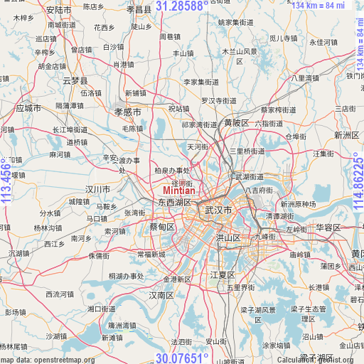
Mintian GPS coordinates[2]
30° 40' 59.124" North, 114° 9' 32.832" East
| Map corner | latitude | longitude |
|---|---|---|
| Upper-left | 31.28588°, | 113.456° |
| Center: | 30.68309°, | 114.15912° |
| Lower-right: | 30.07651°, | 114.86225° |
| Map W x H: | 134.5×134.5 km | = 83.6×83.6mi |
| max Lat: | 53.31946° ⇑48% North |
| Mintian: | 30.68309° |
| min Lat: | ⇓52% South 18.22056° |
| min Long | Mintian | max Long |
| 75.07348° | 114.15912° | 134.28917° |
| W 49.6%⇐ | ⇒50.4% E |
Elevation
Elevation of Mintian is 26 m = 85 ft, and this is 458.8 m = 1505 ft below average elevation for this country.
| Max E: |
5622 m = 18445 ft | 80.2% |
| Avg. | 484.8 m = 1591 ft | |
| Mintian | 26 m = 85 ft | |
Min E: |
-3 m = -10 ft | 19.8% |
See also: China elevation on elevation.city.
Geographical zone
Mintian is located in North temperate zone (between Tropic of Cancer and the Arctic Circle). Distance of this Northern Tropic circle is 805.7 km =500.6 mi to South.| Distance of | km | miles | from Mintian |
|---|---|---|---|
| North Pole | 6595.4 | 4098.2 | to North |
| Arctic Circle | 3989.5 | 2479 | to North |
| Tropic Cancer | 805.7 | 500.6 | to South |
| Equator | 3411.6 | 2119.9 | to South |


Nearby cities:
15 places around Mintian: (largest is in red/bold)
• Caidian
16.4 km =10.2 mi,  227°
227°
• Changfeng
9.6 km =6 mi,  151°
151°
• Changqing
8.6 km =5.3 mi,  207°
207°
• Dongshan
17.3 km =10.7 mi,  306°
306°
• Houhu
16.1 km =10 mi,  99°
99°
• Jiang’an Qu
16.4 km =10.2 mi,  120°
120°
• Maomiaoji
6.6 km =4.1 mi,  322°
322°
• Sandian
3.6 km =2.2 mi,  190°
190°
• Shilipu
14.5 km =9 mi,  158°
158°
• Tianhe
14.4 km =8.9 mi,  21°
21°
• Wuhan
15.1 km =9.4 mi,  137°
137°
• Wujiashan
7.8 km =4.8 mi,  199°
199°
• Xingou
17.7 km =11 mi,  253°
253°
• Yongfeng
14.3 km =8.9 mi, 155°
• Zoumaling
14.1 km =8.8 mi,  256°
256°
Sources, notices
• [Note1] Compared only with cities in China existing in our database
• [Src1] Map data: © OpenStreetMap contributors (CC-BY-SA)
• [Src2] Other city data from geonames.org with taken over terms of usage.
• [Src3] Geographical zone / Annual Mean Temperature by Robert A. Rohde @ Wikipedia
