Wangying geodata
Wangying (Jiangsu) is a seat of a fourth-order administrative division; located in China in Asia/Shanghai (GMT+8) time zone. In our database, there are 1268 cities with bigger population. Compared to other cities in China, 66.3% of cities are located further ↓South; 78.9% of cities are located further ←West and 98.9% of cities have higher elevation than Wangying. Note1


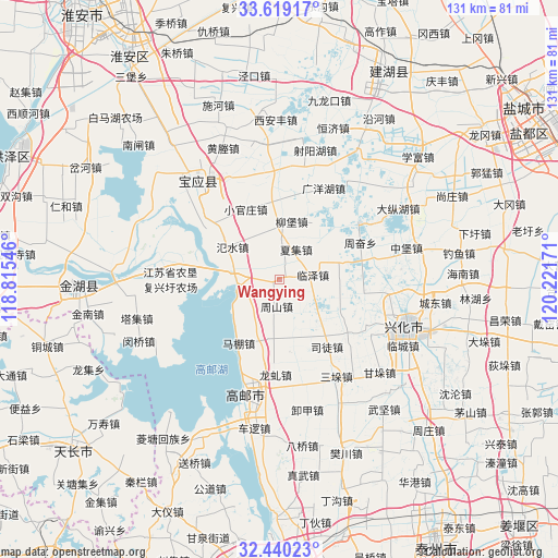
Wangying GPS coordinates[2]
33° 1' 54.012" North, 119° 31' 6.888" East
| Map corner | latitude | longitude |
|---|---|---|
| Upper-left | 33.61917°, | 118.81546° |
| Center: | 33.03167°, | 119.51858° |
| Lower-right: | 32.44023°, | 120.22171° |
| Map W x H: | 131.1×131.1 km | = 81.5×81.5mi |
| max Lat: | 53.31946° ⇑33.7% North |
| Wangying: | 33.03167° |
| min Lat: | ⇓66.3% South 18.22056° |
| min Long | Wangying | max Long |
| 75.07348° | 119.51858° | 134.28917° |
| W 78.9%⇐ | ⇒21.1% E |
Elevation
Elevation of Wangying is 3 m = 10 ft, and this is 481.8 m = 1581 ft below average elevation for this country.
| Max E: |
5622 m = 18445 ft | 98.9% |
| Avg. | 484.8 m = 1591 ft | |
| Wangying | 3 m = 10 ft | |
Min E: |
-3 m = -10 ft | 1.1% |
See also: China elevation on elevation.city.
Geographical zone
Wangying is located in North temperate zone (between Tropic of Cancer and the Arctic Circle). Distance of this Northern Tropic circle is 1066.9 km =662.9 mi to South.| Distance of | km | miles | from Wangying |
|---|---|---|---|
| North Pole | 6334.3 | 3936 | to North |
| Arctic Circle | 3728.4 | 2316.7 | to North |
| Tropic Cancer | 1066.9 | 662.9 | to South |
| Equator | 3672.8 | 2282.2 | to South |


Nearby cities:
15 places around Wangying: (largest is in red/bold)
• Baoying
29.4 km =18.3 mi,  318°
318°
• Ganduo
28.5 km =17.7 mi,  127°
127°
• Gaoyou
27.9 km =17.3 mi,  194°
194°
• Gaoyou
28.7 km =17.8 mi, 188°
• Hengjing
20.6 km =12.8 mi, 128°
• Huying
8.2 km =5.1 mi,  303°
303°
• Longqiu
22.5 km =14 mi,  181°
181°
• Mapeng
17.8 km =11.1 mi,  211°
211°
• Sanduo
27.1 km =16.8 mi,  150°
150°
• Shaoyang
29.6 km =18.4 mi,  114°
114°
• Situ
19.4 km =12.1 mi, 145°
• Xijiao
21.8 km =13.5 mi, 110°
• Yigou
25.6 km =15.9 mi, 178°
• Zhoushan
6.6 km =4.1 mi, 186°
• Zhouxiang
5.6 km =3.5 mi,  119°
119°
Sources, notices
• [Note1] Compared only with cities in China existing in our database
• [Src1] Map data: © OpenStreetMap contributors (CC-BY-SA)
• [Src2] Other city data from geonames.org with taken over terms of usage.
• [Src3] Geographical zone / Annual Mean Temperature by Robert A. Rohde @ Wikipedia
