Baoying geodata
Baoying (Jiangsu) is a populated place; located in China in Asia/Shanghai (GMT+8) time zone. With population of 80,292 people, there are 530 cities with bigger population in this country. Compared to other cities in China, 67.1% of cities are located further ↓South; 77.7% of cities are located further ←West and 98.3% of cities have higher elevation than Baoying. Note1


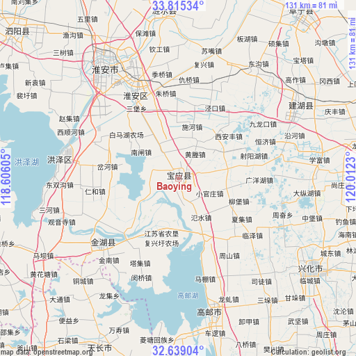
Baoying GPS coordinates[2]
33° 13' 45.012" North, 119° 18' 33.012" East
| Map corner | latitude | longitude |
|---|---|---|
| Upper-left | 33.81534°, | 118.60605° |
| Center: | 33.22917°, | 119.30917° |
| Lower-right: | 32.63904°, | 120.0123° |
| Map W x H: | 130.8×130.8 km | = 81.3×81.3mi |
| max Lat: | 53.31946° ⇑32.9% North |
| Baoying: | 33.22917° |
| min Lat: | ⇓67.1% South 18.22056° |
| min Long | Baoying | max Long |
| 75.07348° | 119.30917° | 134.28917° |
| W 77.7%⇐ | ⇒22.3% E |
Elevation
Elevation of Baoying is 4 m = 13 ft, and this is 480.8 m = 1577 ft below average elevation for this country.
| Max E: |
5622 m = 18445 ft | 98.3% |
| Avg. | 484.8 m = 1591 ft | |
| Baoying | 4 m = 13 ft | |
Min E: |
-3 m = -10 ft | 1.7% |
See also: Baoying elevation on elevation.city.
Geographical zone
Baoying is located in North temperate zone (between Tropic of Cancer and the Arctic Circle). Distance of this Northern Tropic circle is 1088.8 km =676.5 mi to South.| Distance of | km | miles | from Baoying |
|---|---|---|---|
| North Pole | 6312.3 | 3922.3 | to North |
| Arctic Circle | 3706.4 | 2303 | to North |
| Tropic Cancer | 1088.8 | 676.5 | to South |
| Equator | 3694.7 | 2295.8 | to South |


Nearby cities:
15 places around Baoying: (largest is in red/bold)
• Gaomiaoji
44.3 km =27.5 mi,  221°
221°
• Gaoyou
50.4 km =31.3 mi,  165°
165°
• Hengjing
49.8 km =30.9 mi,  134°
134°
• Huai'an
48.2 km =30 mi,  326°
326°
• Huying
21.5 km =13.4 mi,  144°
144°
• Jinnan
39.5 km =24.5 mi, 219°
• Longqiu
48.4 km =30.1 mi,  156°
156°
• Mapeng
38.5 km =23.9 mi, 164°
• Minqiao
38.7 km =24 mi,  200°
200°
• Situ
48.7 km =30.3 mi, 141°
• Taji
34.2 km =21.3 mi, 204°
• Wangying
29.4 km =18.3 mi, 138°
• Xijiao
49.6 km =30.8 mi, 126°
• Zhoushan
34.1 km =21.2 mi,  146°
146°
• Zhouxiang
34.7 km =21.6 mi, 135°
Sources, notices
• [Note1] Compared only with cities in China existing in our database
• [Src1] Map data: © OpenStreetMap contributors (CC-BY-SA)
• [Src2] Other city data from geonames.org with taken over terms of usage.
• [Src3] Geographical zone / Annual Mean Temperature by Robert A. Rohde @ Wikipedia
