Huying geodata
Huying (Jiangsu) is a seat of a fourth-order administrative division; located in China in Asia/Shanghai (GMT+8) time zone. In our database, there are 1268 cities with bigger population. Compared to other cities in China, 66.5% of cities are located further ↓South; 78.4% of cities are located further ←West and 95.9% of cities have higher elevation than Huying. Note1


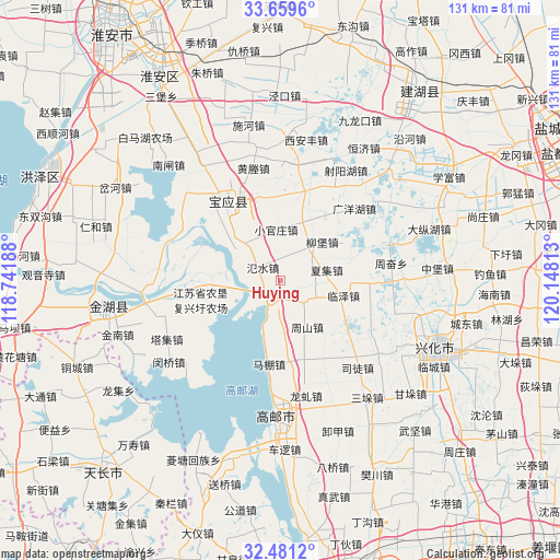
Huying GPS coordinates[2]
33° 4' 20.532" North, 119° 26' 42" East
| Map corner | latitude | longitude |
|---|---|---|
| Upper-left | 33.6596°, | 118.74188° |
| Center: | 33.07237°, | 119.445° |
| Lower-right: | 32.4812°, | 120.14813° |
| Map W x H: | 131×131 km | = 81.4×81.4mi |
| max Lat: | 53.31946° ⇑33.5% North |
| Huying: | 33.07237° |
| min Lat: | ⇓66.5% South 18.22056° |
| min Long | Huying | max Long |
| 75.07348° | 119.445° | 134.28917° |
| W 78.4%⇐ | ⇒21.6% E |
Elevation
Elevation of Huying is 6 m = 20 ft, and this is 478.8 m = 1571 ft below average elevation for this country.
| Max E: |
5622 m = 18445 ft | 95.9% |
| Avg. | 484.8 m = 1591 ft | |
| Huying | 6 m = 20 ft | |
Min E: |
-3 m = -10 ft | 4.1% |
See also: China elevation on elevation.city.
Geographical zone
Huying is located in North temperate zone (between Tropic of Cancer and the Arctic Circle). Distance of this Northern Tropic circle is 1071.4 km =665.7 mi to South.| Distance of | km | miles | from Huying |
|---|---|---|---|
| North Pole | 6329.8 | 3933.2 | to North |
| Arctic Circle | 3723.9 | 2313.9 | to North |
| Tropic Cancer | 1071.4 | 665.7 | to South |
| Equator | 3677.3 | 2285 | to South |


Nearby cities:
15 places around Huying: (largest is in red/bold)
• Baoying
21.5 km =13.4 mi,  324°
324°
• Gaoyou
31.5 km =19.6 mi,  180°
180°
• Gaoyou
33 km =20.5 mi, 175°
• Hengjing
28.8 km =17.9 mi,  126°
126°
• Longqiu
27.8 km =17.3 mi,  166°
166°
• Mapeng
19.9 km =12.4 mi,  187°
187°
• Minqiao
32.1 km =19.9 mi,  233°
233°
• Sanduo
34.6 km =21.5 mi,  144°
144°
• Situ
27.2 km =16.9 mi, 138°
• Taji
30.1 km =18.7 mi,  242°
242°
• Wangying
8.2 km =5.1 mi,  123°
123°
• Xijiao
29.8 km =18.5 mi,  114°
114°
• Yigou
31 km =19.3 mi, 166°
• Zhoushan
12.7 km =7.9 mi,  150°
150°
• Zhouxiang
13.8 km =8.6 mi, 121°
Sources, notices
• [Note1] Compared only with cities in China existing in our database
• [Src1] Map data: © OpenStreetMap contributors (CC-BY-SA)
• [Src2] Other city data from geonames.org with taken over terms of usage.
• [Src3] Geographical zone / Annual Mean Temperature by Robert A. Rohde @ Wikipedia
