Anning geodata
Anning (Hunan) is a seat of a fourth-order administrative division; located in China in Asia/Shanghai (GMT+8) time zone. In our database, there are 1268 cities with bigger population. Compared to other cities in China, 59.7% of cities are located further ↑North; 62.4% of cities are located further →East and 75.7% of cities have higher elevation than Anning. Note1


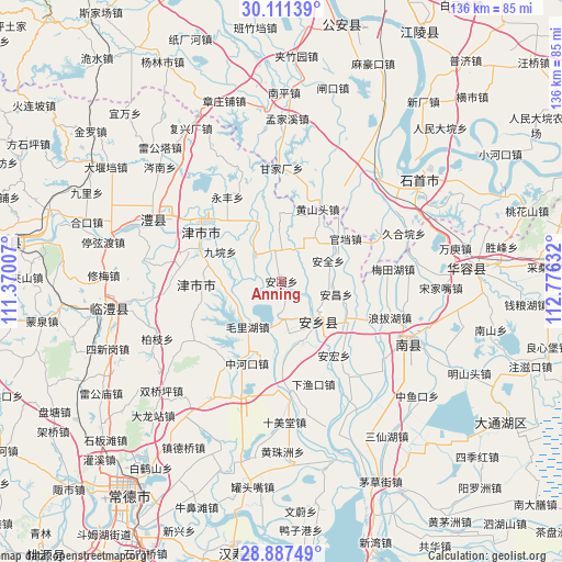
Anning GPS coordinates[2]
29° 30' 4.644" North, 112° 4' 23.484" East
| Map corner | latitude | longitude |
|---|---|---|
| Upper-left | 30.11139°, | 111.37007° |
| Center: | 29.50129°, | 112.07319° |
| Lower-right: | 28.88749°, | 112.77632° |
| Map W x H: | 136.1×136.1 km | = 84.6×84.6mi |
| max Lat: | 53.31946° ⇑59.7% North |
| Anning: | 29.50129° |
| min Lat: | ⇓40.3% South 18.22056° |
| min Long | Anning | max Long |
| 75.07348° | 112.07319° | 134.28917° |
| W 37.6%⇐ | ⇒62.4% E |
Elevation
Elevation of Anning is 35 m = 115 ft, and this is 449.8 m = 1476 ft below average elevation for this country.
| Max E: |
5622 m = 18445 ft | 75.7% |
| Avg. | 484.8 m = 1591 ft | |
| Anning | 35 m = 115 ft | |
Min E: |
-3 m = -10 ft | 24.3% |
See also: China elevation on elevation.city.
Geographical zone
Anning is located in North temperate zone (between Tropic of Cancer and the Arctic Circle). Distance of this Northern Tropic circle is 674.3 km =419 mi to South.| Distance of | km | miles | from Anning |
|---|---|---|---|
| North Pole | 6726.8 | 4179.8 | to North |
| Arctic Circle | 4120.9 | 2560.6 | to North |
| Tropic Cancer | 674.3 | 419 | to South |
| Equator | 3280.2 | 2038.2 | to South |


Nearby cities:
15 places around Anning: (largest is in red/bold)
• Anfeng
9.3 km =5.8 mi,  183°
183°
• Anxiang
13.5 km =8.4 mi,  146°
146°
• Anyu
14.1 km =8.8 mi,  172°
172°
• Baiyi
20 km =12.4 mi,  255°
255°
• Baohedi
13.4 km =8.3 mi,  216°
216°
• Dukou
23.3 km =14.5 mi,  214°
214°
• Guanyuan
8.8 km =5.5 mi,  316°
316°
• Jiaoqi
16.4 km =10.2 mi,  2°
2°
• Jinshi
22.8 km =14.2 mi,  300°
300°
• Jiuyuan
16.4 km =10.2 mi, 296°
• Lijiapu
14.9 km =9.3 mi,  268°
268°
• Xiaodukou
21 km =13 mi,  312°
312°
• Xinzhou
19.5 km =12.1 mi,  287°
287°
• Yongfeng
24.2 km =15 mi,  327°
327°
• Zhonghekou
21.6 km =13.4 mi,  202°
202°
Sources, notices
• [Note1] Compared only with cities in China existing in our database
• [Src1] Map data: © OpenStreetMap contributors (CC-BY-SA)
• [Src2] Other city data from geonames.org with taken over terms of usage.
• [Src3] Geographical zone / Annual Mean Temperature by Robert A. Rohde @ Wikipedia
