Anyu geodata
Anyu (Hunan) is a seat of a fourth-order administrative division; located in China in Asia/Shanghai (GMT+8) time zone. In our database, there are 1268 cities with bigger population. Compared to other cities in China, 61% of cities are located further ↑North; 62.3% of cities are located further →East and 77.7% of cities have higher elevation than Anyu. Note1


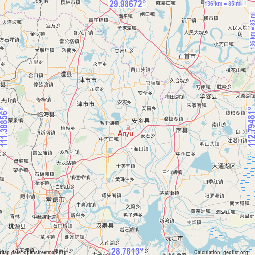
Anyu GPS coordinates[2]
29° 22' 33.06" North, 112° 5' 30.048" East
| Map corner | latitude | longitude |
|---|---|---|
| Upper-left | 29.98672°, | 111.38856° |
| Center: | 29.37585°, | 112.09168° |
| Lower-right: | 28.7613°, | 112.79481° |
| Map W x H: | 136.3×136.3 km | = 84.7×84.7mi |
| max Lat: | 53.31946° ⇑61% North |
| Anyu: | 29.37585° |
| min Lat: | ⇓39% South 18.22056° |
| min Long | Anyu | max Long |
| 75.07348° | 112.09168° | 134.28917° |
| W 37.7%⇐ | ⇒62.3% E |
Elevation
Elevation of Anyu is 31 m = 102 ft, and this is 453.8 m = 1489 ft below average elevation for this country.
| Max E: |
5622 m = 18445 ft | 77.7% |
| Avg. | 484.8 m = 1591 ft | |
| Anyu | 31 m = 102 ft | |
Min E: |
-3 m = -10 ft | 22.3% |
See also: China elevation on elevation.city.
Geographical zone
Anyu is located in North temperate zone (between Tropic of Cancer and the Arctic Circle). Distance of this Northern Tropic circle is 660.4 km =410.4 mi to South.| Distance of | km | miles | from Anyu |
|---|---|---|---|
| North Pole | 6740.8 | 4188.5 | to North |
| Arctic Circle | 4134.9 | 2569.3 | to North |
| Tropic Cancer | 660.4 | 410.4 | to South |
| Equator | 3266.3 | 2029.6 | to South |


Nearby cities:
15 places around Anyu: (largest is in red/bold)
• Anfeng
5.3 km =3.3 mi,  332°
332°
• Anning
14.1 km =8.8 mi,  352°
352°
• Anxiang
6.3 km =3.9 mi,  64°
64°
• Baiyi
22.9 km =14.2 mi,  292°
292°
• Baohedi
10.3 km =6.4 mi, 288°
• Dukou
16 km =9.9 mi,  251°
251°
• Guanyuan
21.8 km =13.5 mi,  338°
338°
• Haozigang
12.1 km =7.5 mi,  196°
196°
• Lijiapu
21.5 km =13.4 mi,  308°
308°
• Mahekou
20.3 km =12.6 mi,  115°
115°
• Shimeitang
20.4 km =12.7 mi,  185°
185°
• Tanghua
21.9 km =13.6 mi,  268°
268°
• Zhonghekou
11.7 km =7.3 mi,  239°
239°
• Zhoujiadian
23.4 km =14.5 mi,  232°
232°
• Zhufeng
21.7 km =13.5 mi,  212°
212°
Sources, notices
• [Note1] Compared only with cities in China existing in our database
• [Src1] Map data: © OpenStreetMap contributors (CC-BY-SA)
• [Src2] Other city data from geonames.org with taken over terms of usage.
• [Src3] Geographical zone / Annual Mean Temperature by Robert A. Rohde @ Wikipedia
