Jiulonghu geodata
Jiulonghu (Zhejiang) is a seat of a fourth-order administrative division; located in China in Asia/Shanghai (GMT+8) time zone. In our database, there are 1268 cities with bigger population. Compared to other cities in China, 53.6% of cities are located further ↑North; 90.2% of cities are located further ←West and 75.3% of cities have higher elevation than Jiulonghu. Note1


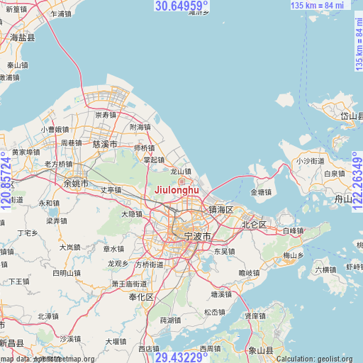
Jiulonghu GPS coordinates[2]
30° 2' 34.116" North, 121° 33' 37.296" East
| Map corner | latitude | longitude |
|---|---|---|
| Upper-left | 30.64959°, | 120.85724° |
| Center: | 30.04281°, | 121.56036° |
| Lower-right: | 29.43229°, | 122.26349° |
| Map W x H: | 135.4×135.4 km | = 84.1×84.1mi |
| max Lat: | 53.31946° ⇑53.6% North |
| Jiulonghu: | 30.04281° |
| min Lat: | ⇓46.4% South 18.22056° |
| min Long | Jiulonghu | max Long |
| 75.07348° | 121.56036° | 134.28917° |
| W 90.2%⇐ | ⇒9.8% E |
Elevation
Elevation of Jiulonghu is 36 m = 118 ft, and this is 448.8 m = 1472 ft below average elevation for this country.
| Max E: |
5622 m = 18445 ft | 75.3% |
| Avg. | 484.8 m = 1591 ft | |
| Jiulonghu | 36 m = 118 ft | |
Min E: |
-3 m = -10 ft | 24.7% |
See also: China elevation on elevation.city.
Geographical zone
Jiulonghu is located in North temperate zone (between Tropic of Cancer and the Arctic Circle). Distance of this Northern Tropic circle is 734.5 km =456.4 mi to South.| Distance of | km | miles | from Jiulonghu |
|---|---|---|---|
| North Pole | 6666.6 | 4142.4 | to North |
| Arctic Circle | 4060.7 | 2523.2 | to North |
| Tropic Cancer | 734.5 | 456.4 | to South |
| Equator | 3340.4 | 2075.6 | to South |


Nearby cities:
15 places around Jiulonghu: (largest is in red/bold)
• Cicheng
13.4 km =8.3 mi,  239°
239°
• Dongjiao
18.8 km =11.7 mi,  172°
172°
• Gaoqiao
18.1 km =11.2 mi,  214°
214°
• Hongtang
11.4 km =7.1 mi, 207°
• Longshan
4 km =2.5 mi,  349°
349°
• Luotuo
7.1 km =4.4 mi,  156°
156°
• Ningbo
18.3 km =11.4 mi,  183°
183°
• Sanbei
8.3 km =5.2 mi,  314°
314°
• Xiepu
3.8 km =2.4 mi,  122°
122°
• Yangjia
11.3 km =7 mi, 307°
• Yongjiang
15.5 km =9.6 mi, 173°
• Zhangqi
13.3 km =8.3 mi, 307°
• Zhaobaoshan
14.7 km =9.1 mi, 123°
• Zhuangqiao
12.6 km =7.8 mi,  185°
185°
• Zhuangshi
13.1 km =8.1 mi, 158°
Sources, notices
• [Note1] Compared only with cities in China existing in our database
• [Src1] Map data: © OpenStreetMap contributors (CC-BY-SA)
• [Src2] Other city data from geonames.org with taken over terms of usage.
• [Src3] Geographical zone / Annual Mean Temperature by Robert A. Rohde @ Wikipedia
