Binhu geodata
Binhu (Jiangsu) is a seat of a third-order administrative division; located in China in Asia/Shanghai (GMT+8) time zone. In our database, there are 1268 cities with bigger population. Compared to other cities in China, 61.3% of cities are located further ↓South; 74.7% of cities are located further ←West and 99.7% of cities have higher elevation than Binhu. Note1


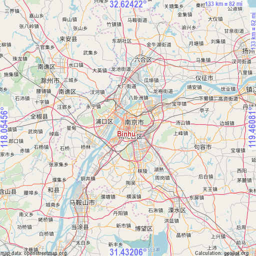
Binhu GPS coordinates[2]
32° 1' 48.288" North, 118° 45' 27.648" East
| Map corner | latitude | longitude |
|---|---|---|
| Upper-left | 32.62422°, | 118.05456° |
| Center: | 32.03008°, | 118.75768° |
| Lower-right: | 31.43206°, | 119.46081° |
| Map W x H: | 132.6×132.6 km | = 82.4×82.4mi |
| max Lat: | 53.31946° ⇑38.7% North |
| Binhu: | 32.03008° |
| min Lat: | ⇓61.3% South 18.22056° |
| min Long | Binhu | max Long |
| 75.07348° | 118.75768° | 134.28917° |
| W 74.7%⇐ | ⇒25.3% E |
Elevation
Elevation of Binhu is 1 m = 3 ft, and this is 483.8 m = 1587 ft below average elevation for this country.
| Max E: |
5622 m = 18445 ft | 99.7% |
| Avg. | 484.8 m = 1591 ft | |
| Binhu | 1 m = 3 ft | |
Min E: |
-3 m = -10 ft | 0.3% |
See also: China elevation on elevation.city.
Geographical zone
Binhu is located in North temperate zone (between Tropic of Cancer and the Arctic Circle). Distance of this Northern Tropic circle is 955.5 km =593.7 mi to South.| Distance of | km | miles | from Binhu |
|---|---|---|---|
| North Pole | 6445.7 | 4005.2 | to North |
| Arctic Circle | 3839.8 | 2385.9 | to North |
| Tropic Cancer | 955.5 | 593.7 | to South |
| Equator | 3561.4 | 2213 | to South |


Nearby cities:
15 places around Binhu: (largest is in red/bold)
• Baotaqiao
9.4 km =5.8 mi,  357°
357°
• Dingshan
11.9 km =7.4 mi,  322°
322°
• Dongshan
10.9 km =6.8 mi,  139°
139°
• Jiangpu
13.1 km =8.1 mi,  285°
285°
• Jiangxinzhou
6.3 km =3.9 mi,  248°
248°
• Ma’qun
12.6 km =7.8 mi,  77°
77°
• Meiyuan Xincun
4.3 km =2.7 mi,  50°
50°
• Mufushan
9.5 km =5.9 mi,  8°
8°
• Nanjing
4 km =2.5 mi,  28°
28°
• Ningnan
5.5 km =3.4 mi,  155°
155°
• Qinhong
4.2 km =2.6 mi,  119°
119°
• Wulaocun
3.6 km =2.2 mi, 82°
• Xiaolingwei
9.1 km =5.7 mi,  88°
88°
• Xiaoshi
7.8 km =4.8 mi,  16°
16°
• Zhujiang
13.4 km =8.3 mi, 285°
Sources, notices
• [Note1] Compared only with cities in China existing in our database
• [Src1] Map data: © OpenStreetMap contributors (CC-BY-SA)
• [Src2] Other city data from geonames.org with taken over terms of usage.
• [Src3] Geographical zone / Annual Mean Temperature by Robert A. Rohde @ Wikipedia
