Ningnan geodata
Ningnan (Jiangsu) is a seat of a third-order administrative division; located in China in Asia/Shanghai (GMT+8) time zone. In our database, there are 1268 cities with bigger population. Compared to other cities in China, 61.1% of cities are located further ↓South; 74.9% of cities are located further ←West and 82.1% of cities have higher elevation than Ningnan. Note1


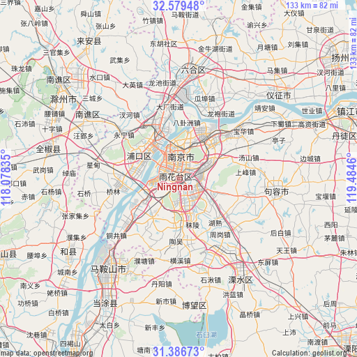
Ningnan GPS coordinates[2]
31° 59' 6.144" North, 118° 46' 53.292" East
| Map corner | latitude | longitude |
|---|---|---|
| Upper-left | 32.57948°, | 118.07835° |
| Center: | 31.98504°, | 118.78147° |
| Lower-right: | 31.38673°, | 119.4846° |
| Map W x H: | 132.6×132.6 km | = 82.4×82.4mi |
| max Lat: | 53.31946° ⇑38.9% North |
| Ningnan: | 31.98504° |
| min Lat: | ⇓61.1% South 18.22056° |
| min Long | Ningnan | max Long |
| 75.07348° | 118.78147° | 134.28917° |
| W 74.9%⇐ | ⇒25.1% E |
Elevation
Elevation of Ningnan is 22 m = 72 ft, and this is 462.8 m = 1518 ft below average elevation for this country.
| Max E: |
5622 m = 18445 ft | 82.1% |
| Avg. | 484.8 m = 1591 ft | |
| Ningnan | 22 m = 72 ft | |
Min E: |
-3 m = -10 ft | 17.9% |
See also: China elevation on elevation.city.
Geographical zone
Ningnan is located in North temperate zone (between Tropic of Cancer and the Arctic Circle). Distance of this Northern Tropic circle is 950.5 km =590.6 mi to South.| Distance of | km | miles | from Ningnan |
|---|---|---|---|
| North Pole | 6450.7 | 4008.3 | to North |
| Arctic Circle | 3844.8 | 2389 | to North |
| Tropic Cancer | 950.5 | 590.6 | to South |
| Equator | 3556.4 | 2209.8 | to South |


Nearby cities:
15 places around Ningnan: (largest is in red/bold)
• Baotaqiao
14.6 km =9.1 mi,  349°
349°
• Binhu
5.5 km =3.4 mi,  335°
335°
• Dingshan
17.3 km =10.7 mi,  326°
326°
• Dongshan
5.8 km =3.6 mi,  124°
124°
• Guli
14.6 km =9.1 mi,  219°
219°
• Jiangpu
17.1 km =10.6 mi,  299°
299°
• Jiangxinzhou
8.6 km =5.3 mi,  288°
288°
• Ma’qun
12.7 km =7.9 mi,  52°
52°
• Meiyuan Xincun
7.8 km =4.8 mi,  7°
7°
• Mufushan
14.4 km =8.9 mi,  356°
356°
• Nanjing
8.5 km =5.3 mi, 357°
• Qinhong
3.3 km =2.1 mi,  25°
25°
• Wulaocun
5.6 km =3.5 mi, 13°
• Xiaolingwei
8.6 km =5.3 mi, 52°
• Xiaoshi
12.5 km =7.8 mi,  0°
0°
Sources, notices
• [Note1] Compared only with cities in China existing in our database
• [Src1] Map data: © OpenStreetMap contributors (CC-BY-SA)
• [Src2] Other city data from geonames.org with taken over terms of usage.
• [Src3] Geographical zone / Annual Mean Temperature by Robert A. Rohde @ Wikipedia
