Guangli geodata
Guangli (Guangdong) is a seat of a fourth-order administrative division; located in China in Asia/Shanghai (GMT+8) time zone. In our database, there are 1268 cities with bigger population. Compared to other cities in China, 93.5% of cities are located further ↑North; 59.5% of cities are located further →East and 88.7% of cities have higher elevation than Guangli. Note1


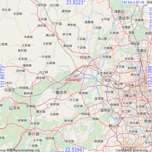
Guangli GPS coordinates[2]
23° 11' 15.18" North, 112° 36' 39.06" East
| Map corner | latitude | longitude |
|---|---|---|
| Upper-left | 23.8323°, | 111.90773° |
| Center: | 23.18755°, | 112.61085° |
| Lower-right: | 22.53967°, | 113.31398° |
| Map W x H: | 143.7×143.7 km | = 89.3×89.3mi |
| max Lat: | 53.31946° ⇑93.5% North |
| Guangli: | 23.18755° |
| min Lat: | ⇓6.5% South 18.22056° |
| min Long | Guangli | max Long |
| 75.07348° | 112.61085° | 134.28917° |
| W 40.5%⇐ | ⇒59.5% E |
Elevation
Elevation of Guangli is 11 m = 36 ft, and this is 473.8 m = 1554 ft below average elevation for this country.
| Max E: |
5622 m = 18445 ft | 88.7% |
| Avg. | 484.8 m = 1591 ft | |
| Guangli | 11 m = 36 ft | |
Min E: |
-3 m = -10 ft | 11.3% |
See also: China elevation on elevation.city.
Geographical zone
Guangli is located in North Torrid zone (between Equator and Tropic of Cancer). Distance of this Northern Tropic circle is 27.7 km =17.2 mi to North.| Distance of | km | miles | from Guangli |
|---|---|---|---|
| North Pole | 7428.8 | 4616 | to North |
| Arctic Circle | 4823 | 2996.9 | to North |
| Tropic Cancer | 27.7 | 17.2 | to North |
| Equator | 2578.2 | 1602 | to South |


Nearby cities:
15 places around Guangli: (largest is in red/bold)
• Chengzhong
18.7 km =11.6 mi,  24°
24°
• Dasha
15.1 km =9.4 mi,  63°
63°
• Dongcheng
19.9 km =12.4 mi,  34°
34°
• Fenghuang
4.9 km =3 mi,  291°
291°
• Guicheng
4.2 km =2.6 mi,  277°
277°
• Huanggang
16.2 km =10.1 mi,  219°
219°
• Jindu
18.1 km =11.2 mi,  212°
212°
• Jinli
20.9 km =13 mi,  125°
125°
• Kengkou
6.6 km =4.1 mi,  234°
234°
• Lianhua
11.4 km =7.1 mi,  42°
42°
• Shapu
7.3 km =4.5 mi,  110°
110°
• Shigou
20.7 km =12.9 mi,  348°
348°
• Xiangang
16.9 km =10.5 mi,  159°
159°
• Yong’an
8 km =5 mi,  96°
96°
• Zhenshan
17.7 km =11 mi, 21°
Sources, notices
• [Note1] Compared only with cities in China existing in our database
• [Src1] Map data: © OpenStreetMap contributors (CC-BY-SA)
• [Src2] Other city data from geonames.org with taken over terms of usage.
• [Src3] Geographical zone / Annual Mean Temperature by Robert A. Rohde @ Wikipedia
