Yong’an geodata
Yong’an (Guangdong) is a seat of a fourth-order administrative division; located in China in Asia/Shanghai (GMT+8) time zone. In our database, there are 1268 cities with bigger population. Compared to other cities in China, 93.6% of cities are located further ↑North; 59.1% of cities are located further →East and 98.3% of cities have higher elevation than Yong’an. Note1


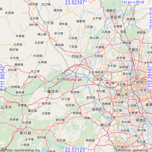
Yong’an GPS coordinates[2]
23° 10' 45.012" North, 112° 41' 18.744" East
| Map corner | latitude | longitude |
|---|---|---|
| Upper-left | 23.82397°, | 111.98542° |
| Center: | 23.17917°, | 112.68854° |
| Lower-right: | 22.53125°, | 113.39167° |
| Map W x H: | 143.7×143.7 km | = 89.3×89.3mi |
| max Lat: | 53.31946° ⇑93.6% North |
| Yong’an: | 23.17917° |
| min Lat: | ⇓6.4% South 18.22056° |
| min Long | Yong’an | max Long |
| 75.07348° | 112.68854° | 134.28917° |
| W 40.9%⇐ | ⇒59.1% E |
Elevation
Elevation of Yong’an is 4 m = 13 ft, and this is 480.8 m = 1577 ft below average elevation for this country.
| Max E: |
5622 m = 18445 ft | 98.3% |
| Avg. | 484.8 m = 1591 ft | |
| Yong’an | 4 m = 13 ft | |
Min E: |
-3 m = -10 ft | 1.7% |
See also: China elevation on elevation.city.
Geographical zone
Yong’an is located in North Torrid zone (between Equator and Tropic of Cancer). Distance of this Northern Tropic circle is 28.6 km =17.8 mi to North.| Distance of | km | miles | from Yong’an |
|---|---|---|---|
| North Pole | 7429.8 | 4616.7 | to North |
| Arctic Circle | 4823.9 | 2997.4 | to North |
| Tropic Cancer | 28.6 | 17.8 | to North |
| Equator | 2577.3 | 1601.5 | to South |


Nearby cities:
15 places around Yong’an: (largest is in red/bold)
• Baini
19.7 km =12.2 mi,  131°
131°
• Chengzhong
17.9 km =11.1 mi,  359°
359°
• Dasha
9.5 km =5.9 mi,  36°
36°
• Dongcheng
17.7 km =11 mi,  11°
11°
• Fenghuang
12.7 km =7.9 mi,  282°
282°
• Guangli
8 km =5 mi, 276°
• Guicheng
12.2 km =7.6 mi, 276°
• Jinli
14.4 km =8.9 mi,  140°
140°
• Kengkou
13.6 km =8.5 mi,  257°
257°
• Lianhua
9.3 km =5.8 mi, 358°
• Longfu
19.9 km =12.4 mi, 5°
• Shapu
1.9 km =1.2 mi,  215°
215°
• Xiangang
15.1 km =9.4 mi,  188°
188°
• Xinan
14.4 km =8.9 mi,  95°
95°
• Zhenshan
17.5 km =10.9 mi, 355°
Sources, notices
• [Note1] Compared only with cities in China existing in our database
• [Src1] Map data: © OpenStreetMap contributors (CC-BY-SA)
• [Src2] Other city data from geonames.org with taken over terms of usage.
• [Src3] Geographical zone / Annual Mean Temperature by Robert A. Rohde @ Wikipedia
