Limiao geodata
Limiao (Hubei) is a seat of a fourth-order administrative division; located in China in Asia/Shanghai (GMT+8) time zone. In our database, there are 1268 cities with bigger population. Compared to other cities in China, 60.3% of cities are located further ↓South; 64.1% of cities are located further →East and 63.3% of cities have lower elevation than Limiao. Note1


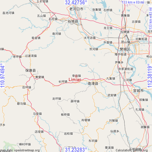
Limiao GPS coordinates[2]
31° 49' 55.668" North, 111° 40' 41.016" East
| Map corner | latitude | longitude |
|---|---|---|
| Upper-left | 32.42756°, | 110.97494° |
| Center: | 31.83213°, | 111.67806° |
| Lower-right: | 31.23283°, | 112.38119° |
| Map W x H: | 132.8×132.8 km | = 82.5×82.5mi |
| max Lat: | 53.31946° ⇑39.7% North |
| Limiao: | 31.83213° |
| min Lat: | ⇓60.3% South 18.22056° |
| min Long | Limiao | max Long |
| 75.07348° | 111.67806° | 134.28917° |
| W 35.9%⇐ | ⇒64.1% E |
Elevation
Elevation of Limiao is 300 m = 984 ft, and this is 184.8 m = 606 ft below average elevation for this country.
| Max E: |
5622 m = 18445 ft | 36.7% |
| Avg. | 484.8 m = 1591 ft | |
| Limiao | 300 m = 984 ft | |
Min E: |
-3 m = -10 ft | 63.3% |
See also: China elevation on elevation.city.
Geographical zone
Limiao is located in North temperate zone (between Tropic of Cancer and the Arctic Circle). Distance of this Northern Tropic circle is 933.5 km =580 mi to South.| Distance of | km | miles | from Limiao |
|---|---|---|---|
| North Pole | 6467.7 | 4018.8 | to North |
| Arctic Circle | 3861.8 | 2399.6 | to North |
| Tropic Cancer | 933.5 | 580 | to South |
| Equator | 3539.4 | 2199.3 | to South |


Nearby cities:
15 places around Limiao: (largest is in red/bold)
• Banqiao
34.7 km =21.6 mi,  194°
194°
• Baokang Chengguanzhen
40.1 km =24.9 mi,  277°
277°
• Changping
12.6 km =7.8 mi,  248°
248°
• Chengguan
16.6 km =10.3 mi,  109°
109°
• Cihe
28.4 km =17.6 mi,  32°
32°
• Huangbao
32 km =19.9 mi,  269°
269°
• Longping
25.9 km =16.1 mi,  221°
221°
• Miaotan
35 km =21.7 mi,  10°
10°
• Nanzhang Chengguanzhen
15.1 km =9.4 mi, 110°
• Nizui
38.5 km =23.9 mi,  56°
56°
• Taipingdian
35.7 km =22.2 mi,  19°
19°
• Xiangcheng
25.4 km =15.8 mi, 62°
• Xiaoyan
39.1 km =24.3 mi,  167°
167°
• Xueping
21.8 km =13.5 mi,  182°
182°
• Yinji
39.3 km =24.4 mi,  72°
72°
Sources, notices
• [Note1] Compared only with cities in China existing in our database
• [Src1] Map data: © OpenStreetMap contributors (CC-BY-SA)
• [Src2] Other city data from geonames.org with taken over terms of usage.
• [Src3] Geographical zone / Annual Mean Temperature by Robert A. Rohde @ Wikipedia
