Zhaiwu geodata
Zhaiwu (Guangdong) is a seat of a fourth-order administrative division; located in China in Asia/Shanghai (GMT+8) time zone. In our database, there are 1268 cities with bigger population. Compared to other cities in China, 95.9% of cities are located further ↑North; 59.4% of cities are located further →East and 80.2% of cities have higher elevation than Zhaiwu. Note1


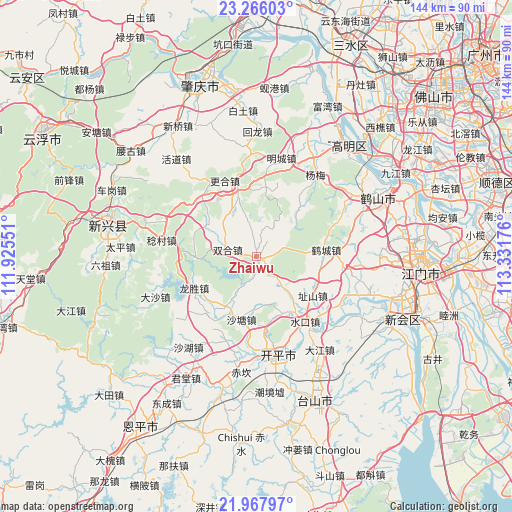
Zhaiwu GPS coordinates[2]
22° 37' 6.708" North, 112° 37' 43.068" East
| Map corner | latitude | longitude |
|---|---|---|
| Upper-left | 23.26603°, | 111.92551° |
| Center: | 22.61853°, | 112.62863° |
| Lower-right: | 21.96797°, | 113.33176° |
| Map W x H: | 144.3×144.3 km | = 89.7×89.7mi |
| max Lat: | 53.31946° ⇑95.9% North |
| Zhaiwu: | 22.61853° |
| min Lat: | ⇓4.1% South 18.22056° |
| min Long | Zhaiwu | max Long |
| 75.07348° | 112.62863° | 134.28917° |
| W 40.6%⇐ | ⇒59.4% E |
Elevation
Elevation of Zhaiwu is 26 m = 85 ft, and this is 458.8 m = 1505 ft below average elevation for this country.
| Max E: |
5622 m = 18445 ft | 80.2% |
| Avg. | 484.8 m = 1591 ft | |
| Zhaiwu | 26 m = 85 ft | |
Min E: |
-3 m = -10 ft | 19.8% |
See also: China elevation on elevation.city.
Geographical zone
Zhaiwu is located in North Torrid zone (between Equator and Tropic of Cancer). Distance of this Northern Tropic circle is 91 km =56.5 mi to North.| Distance of | km | miles | from Zhaiwu |
|---|---|---|---|
| North Pole | 7492.1 | 4655.4 | to North |
| Arctic Circle | 4886.2 | 3036.1 | to North |
| Tropic Cancer | 91 | 56.5 | to North |
| Equator | 2514.9 | 1562.7 | to South |


Nearby cities:
15 places around Zhaiwu: (largest is in red/bold)
• Cangcheng
17.7 km =11 mi,  207°
207°
• Changsha
27 km =16.8 mi,  167°
167°
• Genghe
19.1 km =11.9 mi,  344°
344°
• Gonghe
25.9 km =16.1 mi,  99°
99°
• Hecheng
19.3 km =12 mi,  82°
82°
• Longsheng
19.2 km =11.9 mi,  244°
244°
• Magang
20.9 km =13 mi,  221°
221°
• Rencun
27.3 km =17 mi,  279°
279°
• Shatang
18.3 km =11.4 mi,  193°
193°
• Shuikou
22.9 km =14.2 mi,  142°
142°
• Shuitai
16.5 km =10.3 mi,  270°
270°
• Siqian
26.9 km =16.7 mi,  120°
120°
• Yueshan
18.6 km =11.6 mi,  146°
146°
• Yunxiang
14.7 km =9.1 mi,  113°
113°
• Zhishan
19.5 km =12.1 mi,  125°
125°
Sources, notices
• [Note1] Compared only with cities in China existing in our database
• [Src1] Map data: © OpenStreetMap contributors (CC-BY-SA)
• [Src2] Other city data from geonames.org with taken over terms of usage.
• [Src3] Geographical zone / Annual Mean Temperature by Robert A. Rohde @ Wikipedia
