Huayang geodata
Huayang (Jiangsu) is a seat of a third-order administrative division; located in China in Asia/Shanghai (GMT+8) time zone. In our database, there are 1268 cities with bigger population. Compared to other cities in China, 60.9% of cities are located further ↓South; 76.9% of cities are located further ←West and 81.2% of cities have higher elevation than Huayang. Note1


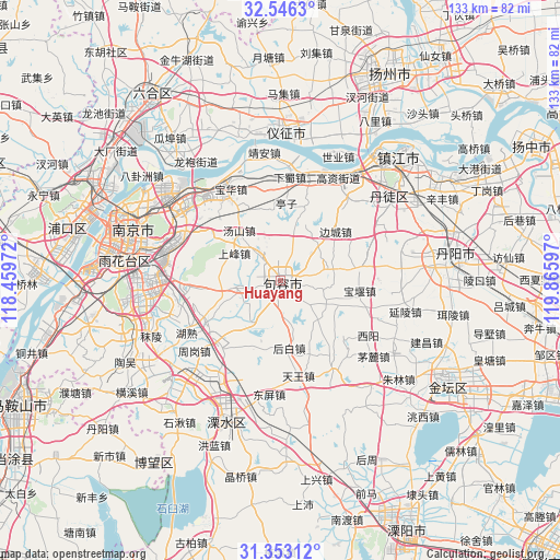
Huayang GPS coordinates[2]
31° 57' 5.94" North, 119° 9' 46.224" East
| Map corner | latitude | longitude |
|---|---|---|
| Upper-left | 32.5463°, | 118.45972° |
| Center: | 31.95165°, | 119.16284° |
| Lower-right: | 31.35312°, | 119.86597° |
| Map W x H: | 132.7×132.7 km | = 82.5×82.5mi |
| max Lat: | 53.31946° ⇑39.1% North |
| Huayang: | 31.95165° |
| min Lat: | ⇓60.9% South 18.22056° |
| min Long | Huayang | max Long |
| 75.07348° | 119.16284° | 134.28917° |
| W 76.9%⇐ | ⇒23.1% E |
Elevation
Elevation of Huayang is 24 m = 79 ft, and this is 460.8 m = 1512 ft below average elevation for this country.
| Max E: |
5622 m = 18445 ft | 81.2% |
| Avg. | 484.8 m = 1591 ft | |
| Huayang | 24 m = 79 ft | |
Min E: |
-3 m = -10 ft | 18.8% |
See also: China elevation on elevation.city.
Geographical zone
Huayang is located in North temperate zone (between Tropic of Cancer and the Arctic Circle). Distance of this Northern Tropic circle is 946.8 km =588.3 mi to South.| Distance of | km | miles | from Huayang |
|---|---|---|---|
| North Pole | 6454.4 | 4010.6 | to North |
| Arctic Circle | 3848.5 | 2391.3 | to North |
| Tropic Cancer | 946.8 | 588.3 | to South |
| Equator | 3552.7 | 2207.5 | to South |


Nearby cities:
15 places around Huayang: (largest is in red/bold)
• Baitu
18.5 km =11.5 mi,  80°
80°
• Baohua
24.6 km =15.3 mi,  331°
331°
• Baoyan
18.8 km =11.7 mi,  100°
100°
• Biancheng
17.3 km =10.7 mi,  48°
48°
• Gaozi
27.5 km =17.1 mi,  28°
28°
• Houbai
16.1 km =10 mi,  174°
174°
• Longtan
26.3 km =16.3 mi,  336°
336°
• Maoshan
21.8 km =13.5 mi,  144°
144°
• Ma’qun
28.4 km =17.6 mi,  293°
293°
• Qixia
29.4 km =18.3 mi,  314°
314°
• Shangdang
26.9 km =16.7 mi,  59°
59°
• Tianwang
23.1 km =14.4 mi, 170°
• Tuqiao
9.9 km =6.2 mi,  262°
262°
• Xiashu
24.7 km =15.3 mi,  5°
5°
• Zhougang
25.7 km =16 mi,  227°
227°
Sources, notices
• [Note1] Compared only with cities in China existing in our database
• [Src1] Map data: © OpenStreetMap contributors (CC-BY-SA)
• [Src2] Other city data from geonames.org with taken over terms of usage.
• [Src3] Geographical zone / Annual Mean Temperature by Robert A. Rohde @ Wikipedia
