Xiashu geodata
Xiashu (Jiangsu) is a seat of a fourth-order administrative division; located in China in Asia/Shanghai (GMT+8) time zone. In our database, there are 1268 cities with bigger population. Compared to other cities in China, 62.3% of cities are located further ↓South; 77% of cities are located further ←West and 86.9% of cities have higher elevation than Xiashu. Note1


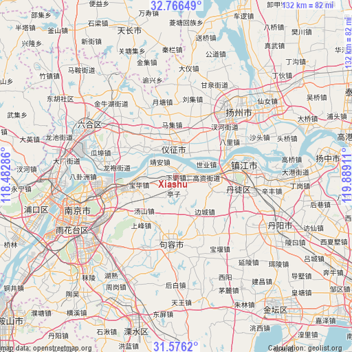
Xiashu GPS coordinates[2]
32° 10' 23.844" North, 119° 11' 9.528" East
| Map corner | latitude | longitude |
|---|---|---|
| Upper-left | 32.76649°, | 118.48286° |
| Center: | 32.17329°, | 119.18598° |
| Lower-right: | 31.5762°, | 119.88911° |
| Map W x H: | 132.3×132.3 km | = 82.2×82.2mi |
| max Lat: | 53.31946° ⇑37.7% North |
| Xiashu: | 32.17329° |
| min Lat: | ⇓62.3% South 18.22056° |
| min Long | Xiashu | max Long |
| 75.07348° | 119.18598° | 134.28917° |
| W 77%⇐ | ⇒23% E |
Elevation
Elevation of Xiashu is 13 m = 43 ft, and this is 471.8 m = 1548 ft below average elevation for this country.
| Max E: |
5622 m = 18445 ft | 86.9% |
| Avg. | 484.8 m = 1591 ft | |
| Xiashu | 13 m = 43 ft | |
Min E: |
-3 m = -10 ft | 13.1% |
See also: China elevation on elevation.city.
Geographical zone
Xiashu is located in North temperate zone (between Tropic of Cancer and the Arctic Circle). Distance of this Northern Tropic circle is 971.4 km =603.6 mi to South.| Distance of | km | miles | from Xiashu |
|---|---|---|---|
| North Pole | 6429.7 | 3995.2 | to North |
| Arctic Circle | 3823.8 | 2376 | to North |
| Tropic Cancer | 971.4 | 603.6 | to South |
| Equator | 3577.3 | 2222.8 | to South |


Nearby cities:
15 places around Xiashu: (largest is in red/bold)
• Baohua
14.4 km =8.9 mi,  257°
257°
• Biancheng
16.9 km =10.5 mi,  140°
140°
• Donggou
21.5 km =13.4 mi,  300°
300°
• Gaozi
10.9 km =6.8 mi,  92°
92°
• Guazhou
20.6 km =12.8 mi,  64°
64°
• Jing’an
7.4 km =4.6 mi,  326°
326°
• Longtan
12.9 km =8 mi,  267°
267°
• Maji
20.2 km =12.6 mi,  354°
354°
• Poxi
18.2 km =11.3 mi,  41°
41°
• Qilidian
20.2 km =12.6 mi, 87°
• Qingshan
13.8 km =8.6 mi,  309°
309°
• Shiye
11.9 km =7.4 mi,  67°
67°
• Xincheng
13.5 km =8.4 mi,  19°
19°
• Xinji
20 km =12.4 mi,  30°
30°
• Zhenzhou
12 km =7.5 mi, 352°
Sources, notices
• [Note1] Compared only with cities in China existing in our database
• [Src1] Map data: © OpenStreetMap contributors (CC-BY-SA)
• [Src2] Other city data from geonames.org with taken over terms of usage.
• [Src3] Geographical zone / Annual Mean Temperature by Robert A. Rohde @ Wikipedia
