Huyuan geodata
Huyuan (Zhejiang) is a seat of a fourth-order administrative division; located in China in Asia/Shanghai (GMT+8) time zone. In our database, there are 1268 cities with bigger population. Compared to other cities in China, 68.8% of cities are located further ↑North; 83.2% of cities are located further ←West and 60.4% of cities have lower elevation than Huyuan. Note1


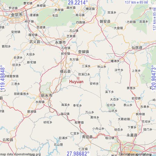
Huyuan GPS coordinates[2]
28° 36' 21.312" North, 120° 12' 5.76" East
| Map corner | latitude | longitude |
|---|---|---|
| Upper-left | 29.2214°, | 119.49848° |
| Center: | 28.60592°, | 120.2016° |
| Lower-right: | 27.98682°, | 120.90473° |
| Map W x H: | 137.3×137.3 km | = 85.3×85.3mi |
| max Lat: | 53.31946° ⇑68.8% North |
| Huyuan: | 28.60592° |
| min Lat: | ⇓31.2% South 18.22056° |
| min Long | Huyuan | max Long |
| 75.07348° | 120.2016° | 134.28917° |
| W 83.2%⇐ | ⇒16.8% E |
Elevation
Elevation of Huyuan is 264 m = 866 ft, and this is 220.8 m = 724 ft below average elevation for this country.
| Max E: |
5622 m = 18445 ft | 39.6% |
| Avg. | 484.8 m = 1591 ft | |
| Huyuan | 264 m = 866 ft | |
Min E: |
-3 m = -10 ft | 60.4% |
See also: China elevation on elevation.city.
Geographical zone
Huyuan is located in North temperate zone (between Tropic of Cancer and the Arctic Circle). Distance of this Northern Tropic circle is 574.8 km =357.2 mi to South.| Distance of | km | miles | from Huyuan |
|---|---|---|---|
| North Pole | 6826.4 | 4241.7 | to North |
| Arctic Circle | 4220.5 | 2622.5 | to North |
| Tropic Cancer | 574.8 | 357.2 | to South |
| Equator | 3180.7 | 1976.4 | to South |


Nearby cities:
15 places around Huyuan: (largest is in red/bold)
• Anling
15 km =9.3 mi,  107°
107°
• Chengbei
17.7 km =11 mi,  313°
313°
• Dayang
12.1 km =7.5 mi,  153°
153°
• Dayuan
11.5 km =7.1 mi,  87°
87°
• Dongdu
14.5 km =9 mi,  276°
276°
• Dongfang
16.9 km =10.5 mi,  347°
347°
• Fangxi
9.2 km =5.7 mi,  220°
220°
• Nanxi
16.1 km =10 mi,  139°
139°
• Qili
16.2 km =10.1 mi,  300°
300°
• Rongjiang
4.6 km =2.9 mi,  28°
28°
• Sanxi
13.1 km =8.1 mi, 34°
• Shijian
14.6 km =9.1 mi,  201°
201°
• Shuangxikou
6.5 km =4 mi,  57°
57°
• Shuhong
6.3 km =3.9 mi,  315°
315°
• Wuyun
14.2 km =8.8 mi,  292°
292°
Sources, notices
• [Note1] Compared only with cities in China existing in our database
• [Src1] Map data: © OpenStreetMap contributors (CC-BY-SA)
• [Src2] Other city data from geonames.org with taken over terms of usage.
• [Src3] Geographical zone / Annual Mean Temperature by Robert A. Rohde @ Wikipedia
