Dayuan geodata
Dayuan (Zhejiang) is a seat of a fourth-order administrative division; located in China in Asia/Shanghai (GMT+8) time zone. In our database, there are 1268 cities with bigger population. Compared to other cities in China, 68.8% of cities are located further ↑North; 84% of cities are located further ←West and 60.1% of cities have lower elevation than Dayuan. Note1


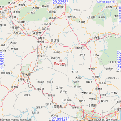
Dayuan GPS coordinates[2]
28° 36' 37.26" North, 120° 19' 8.112" East
| Map corner | latitude | longitude |
|---|---|---|
| Upper-left | 29.2258°, | 119.6158° |
| Center: | 28.61035°, | 120.31892° |
| Lower-right: | 27.99127°, | 121.02205° |
| Map W x H: | 137.3×137.3 km | = 85.3×85.3mi |
| max Lat: | 53.31946° ⇑68.8% North |
| Dayuan: | 28.61035° |
| min Lat: | ⇓31.2% South 18.22056° |
| min Long | Dayuan | max Long |
| 75.07348° | 120.31892° | 134.28917° |
| W 84%⇐ | ⇒16% E |
Elevation
Elevation of Dayuan is 260 m = 853 ft, and this is 224.8 m = 738 ft below average elevation for this country.
| Max E: |
5622 m = 18445 ft | 39.9% |
| Avg. | 484.8 m = 1591 ft | |
| Dayuan | 260 m = 853 ft | |
Min E: |
-3 m = -10 ft | 60.1% |
See also: China elevation on elevation.city.
Geographical zone
Dayuan is located in North temperate zone (between Tropic of Cancer and the Arctic Circle). Distance of this Northern Tropic circle is 575.3 km =357.5 mi to South.| Distance of | km | miles | from Dayuan |
|---|---|---|---|
| North Pole | 6825.9 | 4241.4 | to North |
| Arctic Circle | 4220 | 2622.2 | to North |
| Tropic Cancer | 575.3 | 357.5 | to South |
| Equator | 3181.2 | 1976.7 | to South |


Nearby cities:
15 places around Dayuan: (largest is in red/bold)
• Anling
5.8 km =3.6 mi,  151°
151°
• Dayang
12.7 km =7.9 mi,  208°
208°
• Fangxi
19 km =11.8 mi,  246°
246°
• Hengxi
20.4 km =12.7 mi,  47°
47°
• Huyuan
11.5 km =7.1 mi,  267°
267°
• Jiekeng
19.9 km =12.4 mi,  155°
155°
• Muli
18 km =11.2 mi,  173°
173°
• Nanxi
12.8 km =8 mi,  184°
184°
• Qianlu
18.4 km =11.4 mi,  342°
342°
• Qiushan
13.6 km =8.5 mi,  44°
44°
• Rongjiang
9.9 km =6.2 mi,  290°
290°
• Sanxi
11 km =6.8 mi, 338°
• Shuangxikou
6.7 km =4.2 mi,  296°
296°
• Shuhong
16.4 km =10.2 mi,  284°
284°
• Xixia
20.4 km =12.7 mi,  127°
127°
Sources, notices
• [Note1] Compared only with cities in China existing in our database
• [Src1] Map data: © OpenStreetMap contributors (CC-BY-SA)
• [Src2] Other city data from geonames.org with taken over terms of usage.
• [Src3] Geographical zone / Annual Mean Temperature by Robert A. Rohde @ Wikipedia
