Bayang geodata
Bayang (Chongqing) is a seat of a fourth-order administrative division; located in China in Asia/Shanghai (GMT+8) time zone. In our database, there are 1268 cities with bigger population. Compared to other cities in China, 54.3% of cities are located further ↓South; 78.2% of cities are located further →East and 56% of cities have lower elevation than Bayang. Note1


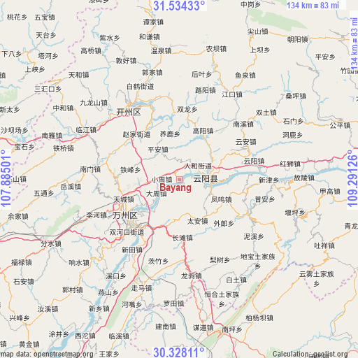
Bayang GPS coordinates[2]
30° 55' 59.232" North, 108° 35' 17.268" East
| Map corner | latitude | longitude |
|---|---|---|
| Upper-left | 31.53433°, | 107.88501° |
| Center: | 30.93312°, | 108.58813° |
| Lower-right: | 30.32811°, | 109.29126° |
| Map W x H: | 134.1×134.1 km | = 83.3×83.3mi |
| max Lat: | 53.31946° ⇑45.7% North |
| Bayang: | 30.93312° |
| min Lat: | ⇓54.3% South 18.22056° |
| min Long | Bayang | max Long |
| 75.07348° | 108.58813° | 134.28917° |
| W 21.8%⇐ | ⇒78.2% E |
Elevation
Elevation of Bayang is 216 m = 709 ft, and this is 268.8 m = 882 ft below average elevation for this country.
| Max E: |
5622 m = 18445 ft | 44% |
| Avg. | 484.8 m = 1591 ft | |
| Bayang | 216 m = 709 ft | |
Min E: |
-3 m = -10 ft | 56% |
See also: China elevation on elevation.city.
Geographical zone
Bayang is located in North temperate zone (between Tropic of Cancer and the Arctic Circle). Distance of this Northern Tropic circle is 833.5 km =517.9 mi to South.| Distance of | km | miles | from Bayang |
|---|---|---|---|
| North Pole | 6567.6 | 4080.9 | to North |
| Arctic Circle | 3961.7 | 2461.7 | to North |
| Tropic Cancer | 833.5 | 517.9 | to South |
| Equator | 3439.4 | 2137.1 | to South |


Nearby cities:
15 places around Bayang: (largest is in red/bold)
• Bayang
13.2 km =8.2 mi,  170°
170°
• Dazhou
10.5 km =6.5 mi,  234°
234°
• Fengwu
16.8 km =10.4 mi,  114°
114°
• Huangbo
2.3 km =1.4 mi,  193°
193°
• Huangshi
14.5 km =9 mi,  59°
59°
• Panlong
12 km =7.5 mi,  104°
104°
• Ping’an
14 km =8.7 mi,  324°
324°
• Qinglong
10.4 km =6.5 mi,  90°
90°
• Renhe
8.9 km =5.5 mi,  50°
50°
• Shuangjiang
8.9 km =5.5 mi,  83°
83°
• Shuikou
18.6 km =11.6 mi, 64°
• Tailong
7.3 km =4.5 mi,  237°
237°
• Tai’an
16.7 km =10.4 mi,  156°
156°
• Xiongjia
15.1 km =9.4 mi,  256°
256°
• Yanglu
17.7 km =11 mi,  348°
348°
Sources, notices
• [Note1] Compared only with cities in China existing in our database
• [Src1] Map data: © OpenStreetMap contributors (CC-BY-SA)
• [Src2] Other city data from geonames.org with taken over terms of usage.
• [Src3] Geographical zone / Annual Mean Temperature by Robert A. Rohde @ Wikipedia
