Fengwu geodata
Fengwu (Chongqing) is a seat of a fourth-order administrative division; located in China in Asia/Shanghai (GMT+8) time zone. In our database, there are 1268 cities with bigger population. Compared to other cities in China, 53.6% of cities are located further ↓South; 77.4% of cities are located further →East and 77.5% of cities have lower elevation than Fengwu. Note1


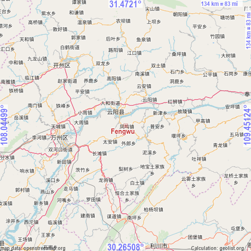
Fengwu GPS coordinates[2]
30° 52' 13.764" North, 108° 44' 53.196" East
| Map corner | latitude | longitude |
|---|---|---|
| Upper-left | 31.4721°, | 108.04499° |
| Center: | 30.87049°, | 108.74811° |
| Lower-right: | 30.26508°, | 109.45124° |
| Map W x H: | 134.2×134.2 km | = 83.4×83.4mi |
| max Lat: | 53.31946° ⇑46.4% North |
| Fengwu: | 30.87049° |
| min Lat: | ⇓53.6% South 18.22056° |
| min Long | Fengwu | max Long |
| 75.07348° | 108.74811° | 134.28917° |
| W 22.6%⇐ | ⇒77.4% E |
Elevation
Elevation of Fengwu is 590 m = 1936 ft, and this is 105.2 m = 345 ft above average elevation for this country.
| Max E: |
5622 m = 18445 ft | 22.5% |
| Fengwu | 590 m 1936 ft | |
| Avg. | 484.8 m = 1591 ft | |
Min E: |
-3 m = -10 ft | 77.5% |
See also: China elevation on elevation.city.
Geographical zone
Fengwu is located in North temperate zone (between Tropic of Cancer and the Arctic Circle). Distance of this Northern Tropic circle is 826.6 km =513.6 mi to South.| Distance of | km | miles | from Fengwu |
|---|---|---|---|
| North Pole | 6574.6 | 4085.3 | to North |
| Arctic Circle | 3968.7 | 2466 | to North |
| Tropic Cancer | 826.6 | 513.6 | to South |
| Equator | 3432.5 | 2132.9 | to South |


Nearby cities:
15 places around Fengwu: (largest is in red/bold)
• Baoping
9.9 km =6.2 mi,  81°
81°
• Bayang
14.4 km =8.9 mi,  245°
245°
• Bayang
16.8 km =10.4 mi,  294°
294°
• Huangbo
16.5 km =10.3 mi, 286°
• Huangshi
14.7 km =9.1 mi,  348°
348°
• Longjiao
12.1 km =7.5 mi,  121°
121°
• Nixi
18.9 km =11.7 mi,  138°
138°
• Panlong
5.4 km =3.4 mi,  317°
317°
• Pu’an
16.9 km =10.5 mi,  90°
90°
• Qinglong
8.5 km =5.3 mi, 324°
• Renhe
15.1 km =9.4 mi,  326°
326°
• Shuangjiang
10.2 km =6.3 mi, 321°
• Shuikou
15.1 km =9.4 mi,  5°
5°
• Tai’an
11.9 km =7.4 mi,  225°
225°
• Wailang
10.8 km =6.7 mi,  170°
170°
Sources, notices
• [Note1] Compared only with cities in China existing in our database
• [Src1] Map data: © OpenStreetMap contributors (CC-BY-SA)
• [Src2] Other city data from geonames.org with taken over terms of usage.
• [Src3] Geographical zone / Annual Mean Temperature by Robert A. Rohde @ Wikipedia
