Shuangjiang geodata
Shuangjiang (Chongqing) is a seat of a third-order administrative division; located in China in Asia/Shanghai (GMT+8) time zone. In our database, there are 1268 cities with bigger population. Compared to other cities in China, 54.4% of cities are located further ↓South; 77.8% of cities are located further →East and 56.8% of cities have lower elevation than Shuangjiang. Note1


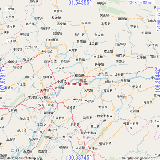
Shuangjiang GPS coordinates[2]
30° 56' 32.64" North, 108° 40' 52.644" East
| Map corner | latitude | longitude |
|---|---|---|
| Upper-left | 31.54355°, | 107.97817° |
| Center: | 30.9424°, | 108.68129° |
| Lower-right: | 30.33745°, | 109.38442° |
| Map W x H: | 134.1×134.1 km | = 83.3×83.3mi |
| max Lat: | 53.31946° ⇑45.6% North |
| Shuangjiang: | 30.9424° |
| min Lat: | ⇓54.4% South 18.22056° |
| min Long | Shuangjiang | max Long |
| 75.07348° | 108.68129° | 134.28917° |
| W 22.2%⇐ | ⇒77.8% E |
Elevation
Elevation of Shuangjiang is 224 m = 735 ft, and this is 260.8 m = 856 ft below average elevation for this country.
| Max E: |
5622 m = 18445 ft | 43.2% |
| Avg. | 484.8 m = 1591 ft | |
| Shuangjiang | 224 m = 735 ft | |
Min E: |
-3 m = -10 ft | 56.8% |
See also: China elevation on elevation.city.
Geographical zone
Shuangjiang is located in North temperate zone (between Tropic of Cancer and the Arctic Circle). Distance of this Northern Tropic circle is 834.6 km =518.6 mi to South.| Distance of | km | miles | from Shuangjiang |
|---|---|---|---|
| North Pole | 6566.6 | 4080.3 | to North |
| Arctic Circle | 3960.7 | 2461.1 | to North |
| Tropic Cancer | 834.6 | 518.6 | to South |
| Equator | 3440.5 | 2137.8 | to South |


Nearby cities:
15 places around Shuangjiang: (largest is in red/bold)
• Baoping
17.5 km =10.9 mi,  111°
111°
• Bayang
8.9 km =5.5 mi,  263°
263°
• Bayang
15.5 km =9.6 mi,  205°
205°
• Dazhou
18.8 km =11.7 mi,  247°
247°
• Fengwu
10.2 km =6.3 mi,  141°
141°
• Gaoyang
17.5 km =10.9 mi,  359°
359°
• Huangbo
10 km =6.2 mi, 250°
• Huangshi
7.3 km =4.5 mi,  28°
28°
• Panlong
4.8 km =3 mi,  145°
145°
• Ping’an
19.9 km =12.4 mi,  301°
301°
• Qinglong
1.8 km =1.1 mi,  124°
124°
• Renhe
5 km =3.1 mi,  336°
336°
• Shuikou
10.6 km =6.6 mi,  48°
48°
• Tailong
15.8 km =9.8 mi, 251°
• Tai’an
16.5 km =10.3 mi,  187°
187°
Sources, notices
• [Note1] Compared only with cities in China existing in our database
• [Src1] Map data: © OpenStreetMap contributors (CC-BY-SA)
• [Src2] Other city data from geonames.org with taken over terms of usage.
• [Src3] Geographical zone / Annual Mean Temperature by Robert A. Rohde @ Wikipedia
