Caohui geodata
Caohui (Chongqing) is a seat of a fourth-order administrative division; located in China in Asia/Shanghai (GMT+8) time zone. In our database, there are 1268 cities with bigger population. Compared to other cities in China, 50.4% of cities are located further ↑North; 82.3% of cities are located further →East and 68.9% of cities have lower elevation than Caohui. Note1


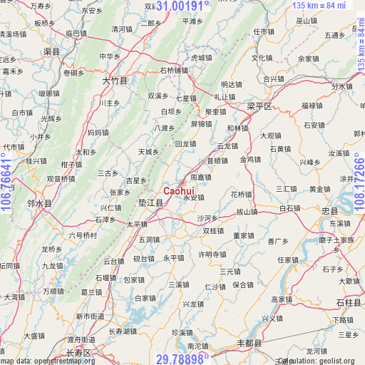
Caohui GPS coordinates[2]
30° 23' 50.388" North, 107° 28' 10.308" East
| Map corner | latitude | longitude |
|---|---|---|
| Upper-left | 31.00191°, | 106.76641° |
| Center: | 30.39733°, | 107.46953° |
| Lower-right: | 29.78898°, | 108.17266° |
| Map W x H: | 134.9×134.9 km | = 83.8×83.8mi |
| max Lat: | 53.31946° ⇑50.4% North |
| Caohui: | 30.39733° |
| min Lat: | ⇓49.6% South 18.22056° |
| min Long | Caohui | max Long |
| 75.07348° | 107.46953° | 134.28917° |
| W 17.7%⇐ | ⇒82.3% E |
Elevation
Elevation of Caohui is 391 m = 1283 ft, and this is 93.8 m = 308 ft below average elevation for this country.
| Max E: |
5622 m = 18445 ft | 31.1% |
| Avg. | 484.8 m = 1591 ft | |
| Caohui | 391 m = 1283 ft | |
Min E: |
-3 m = -10 ft | 68.9% |
See also: China elevation on elevation.city.
Geographical zone
Caohui is located in North temperate zone (between Tropic of Cancer and the Arctic Circle). Distance of this Northern Tropic circle is 773.9 km =480.9 mi to South.| Distance of | km | miles | from Caohui |
|---|---|---|---|
| North Pole | 6627.2 | 4117.9 | to North |
| Arctic Circle | 4021.3 | 2498.7 | to North |
| Tropic Cancer | 773.9 | 480.9 | to South |
| Equator | 3379.9 | 2100.2 | to South |


Nearby cities:
15 places around Caohui: (largest is in red/bold)
• Changlong
11.5 km =7.1 mi,  208°
208°
• Gangjia
19.9 km =12.4 mi,  170°
170°
• Gaofeng
20.6 km =12.8 mi,  196°
196°
• Gao’an
11.9 km =7.4 mi,  183°
183°
• Guixi
13.9 km =8.6 mi,  239°
239°
• Huangsha
17.4 km =10.8 mi, 211°
• Huilong
14.7 km =9.1 mi,  4°
4°
• Pushun
15.3 km =9.5 mi,  56°
56°
• Shaping
9.2 km =5.7 mi,  339°
339°
• Shuanggui
20.6 km =12.8 mi,  146°
146°
• Xinli
21.2 km =13.2 mi,  127°
127°
• Xinmin
7.7 km =4.8 mi,  270°
270°
• Yinping
19 km =11.8 mi,  32°
32°
• Yong’an
6.4 km =4 mi,  139°
139°
• Zhoujia
7 km =4.3 mi,  69°
69°
Sources, notices
• [Note1] Compared only with cities in China existing in our database
• [Src1] Map data: © OpenStreetMap contributors (CC-BY-SA)
• [Src2] Other city data from geonames.org with taken over terms of usage.
• [Src3] Geographical zone / Annual Mean Temperature by Robert A. Rohde @ Wikipedia
