Yong’an geodata
Yong’an (Chongqing) is a seat of a fourth-order administrative division; located in China in Asia/Shanghai (GMT+8) time zone. In our database, there are 1268 cities with bigger population. Compared to other cities in China, 50.7% of cities are located further ↑North; 82.1% of cities are located further →East and 69.9% of cities have lower elevation than Yong’an. Note1


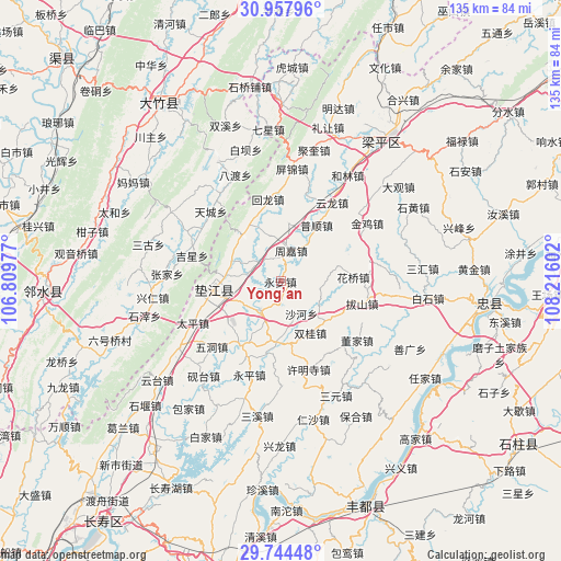
Yong’an GPS coordinates[2]
30° 21' 11.16" North, 107° 30' 46.404" East
| Map corner | latitude | longitude |
|---|---|---|
| Upper-left | 30.95796°, | 106.80977° |
| Center: | 30.3531°, | 107.51289° |
| Lower-right: | 29.74448°, | 108.21602° |
| Map W x H: | 134.9×134.9 km | = 83.8×83.8mi |
| max Lat: | 53.31946° ⇑50.7% North |
| Yong’an: | 30.3531° |
| min Lat: | ⇓49.3% South 18.22056° |
| min Long | Yong’an | max Long |
| 75.07348° | 107.51289° | 134.28917° |
| W 17.9%⇐ | ⇒82.1% E |
Elevation
Elevation of Yong’an is 409 m = 1342 ft, and this is 75.8 m = 249 ft below average elevation for this country.
| Max E: |
5622 m = 18445 ft | 30.1% |
| Avg. | 484.8 m = 1591 ft | |
| Yong’an | 409 m = 1342 ft | |
Min E: |
-3 m = -10 ft | 69.9% |
See also: China elevation on elevation.city.
Geographical zone
Yong’an is located in North temperate zone (between Tropic of Cancer and the Arctic Circle). Distance of this Northern Tropic circle is 769 km =477.8 mi to South.| Distance of | km | miles | from Yong’an |
|---|---|---|---|
| North Pole | 6632.1 | 4121 | to North |
| Arctic Circle | 4026.2 | 2501.8 | to North |
| Tropic Cancer | 769 | 477.8 | to South |
| Equator | 3374.9 | 2097.1 | to South |


Nearby cities:
15 places around Yong’an: (largest is in red/bold)
• Caohui
6.4 km =4 mi,  319°
319°
• Changlong
10.9 km =6.8 mi,  241°
241°
• Dashi
17.2 km =10.7 mi,  172°
172°
• Gangjia
14.8 km =9.2 mi,  183°
183°
• Gaofeng
17.9 km =11.1 mi,  214°
214°
• Gao’an
8.5 km =5.3 mi, 214°
• Guixi
16.2 km =10.1 mi,  262°
262°
• Huangsha
16.5 km =10.3 mi,  232°
232°
• Huaqiao
17.5 km =10.9 mi,  87°
87°
• Pushun
15.8 km =9.8 mi,  33°
33°
• Shaping
15.4 km =9.6 mi,  331°
331°
• Shuanggui
14.2 km =8.8 mi,  149°
149°
• Xinli
15 km =9.3 mi,  122°
122°
• Xinmin
12.8 km =8 mi,  292°
292°
• Zhoujia
7.7 km =4.8 mi,  18°
18°
Sources, notices
• [Note1] Compared only with cities in China existing in our database
• [Src1] Map data: © OpenStreetMap contributors (CC-BY-SA)
• [Src2] Other city data from geonames.org with taken over terms of usage.
• [Src3] Geographical zone / Annual Mean Temperature by Robert A. Rohde @ Wikipedia
