Peixing geodata
Peixing (Chongqing) is a seat of a fourth-order administrative division; located in China in Asia/Shanghai (GMT+8) time zone. In our database, there are 1268 cities with bigger population. Compared to other cities in China, 52.8% of cities are located further ↑North; 82.1% of cities are located further →East and 69% of cities have lower elevation than Peixing. Note1


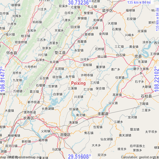
Peixing GPS coordinates[2]
30° 7' 33.924" North, 107° 31' 4.404" East
| Map corner | latitude | longitude |
|---|---|---|
| Upper-left | 30.73236°, | 106.81477° |
| Center: | 30.12609°, | 107.51789° |
| Lower-right: | 29.51608°, | 108.22102° |
| Map W x H: | 135.2×135.2 km | = 84×84mi |
| max Lat: | 53.31946° ⇑52.8% North |
| Peixing: | 30.12609° |
| min Lat: | ⇓47.2% South 18.22056° |
| min Long | Peixing | max Long |
| 75.07348° | 107.51789° | 134.28917° |
| W 17.9%⇐ | ⇒82.1% E |
Elevation
Elevation of Peixing is 392 m = 1286 ft, and this is 92.8 m = 304 ft below average elevation for this country.
| Max E: |
5622 m = 18445 ft | 31% |
| Avg. | 484.8 m = 1591 ft | |
| Peixing | 392 m = 1286 ft | |
Min E: |
-3 m = -10 ft | 69% |
See also: China elevation on elevation.city.
Geographical zone
Peixing is located in North temperate zone (between Tropic of Cancer and the Arctic Circle). Distance of this Northern Tropic circle is 743.8 km =462.2 mi to South.| Distance of | km | miles | from Peixing |
|---|---|---|---|
| North Pole | 6657.4 | 4136.7 | to North |
| Arctic Circle | 4051.5 | 2517.5 | to North |
| Tropic Cancer | 743.8 | 462.2 | to South |
| Equator | 3349.7 | 2081.4 | to South |


Nearby cities:
15 places around Peixing: (largest is in red/bold)
• Baohe
19.1 km =11.9 mi,  112°
112°
• Chongxing
14.5 km =9 mi,  183°
183°
• Dashi
8.4 km =5.2 mi,  12°
12°
• Gangjia
10.6 km =6.6 mi,  352°
352°
• Gaofeng
14.8 km =9.2 mi,  314°
314°
• Gao’an
19 km =11.8 mi,  343°
343°
• Heyou
16.7 km =10.4 mi,  253°
253°
• Pingshan
9.6 km =6 mi, 249°
• Rensha
10.9 km =6.8 mi,  137°
137°
• Sanxi
9.3 km =5.8 mi,  221°
221°
• Sanyuan
13.1 km =8.1 mi,  100°
100°
• Shetan
17.9 km =11.1 mi,  148°
148°
• Shuanggui
14.6 km =9.1 mi,  27°
27°
• Xumingsi
7.3 km =4.5 mi,  57°
57°
• Yantai
19.2 km =11.9 mi,  276°
276°
Sources, notices
• [Note1] Compared only with cities in China existing in our database
• [Src1] Map data: © OpenStreetMap contributors (CC-BY-SA)
• [Src2] Other city data from geonames.org with taken over terms of usage.
• [Src3] Geographical zone / Annual Mean Temperature by Robert A. Rohde @ Wikipedia
