Songnong geodata
Songnong (Chongqing) is a seat of a fourth-order administrative division; located in China in Asia/Shanghai (GMT+8) time zone. In our database, there are 1268 cities with bigger population. Compared to other cities in China, 68.2% of cities are located further ↑North; 75.9% of cities are located further →East and 63.3% of cities have lower elevation than Songnong. Note1


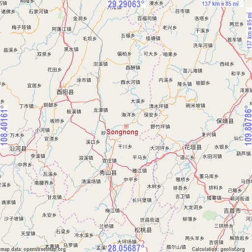
Songnong GPS coordinates[2]
28° 40' 32.052" North, 109° 6' 17.028" East
| Map corner | latitude | longitude |
|---|---|---|
| Upper-left | 29.29063°, | 108.40161° |
| Center: | 28.67557°, | 109.10473° |
| Lower-right: | 28.05687°, | 109.80786° |
| Map W x H: | 137.2×137.2 km | = 85.3×85.3mi |
| max Lat: | 53.31946° ⇑68.2% North |
| Songnong: | 28.67557° |
| min Lat: | ⇓31.8% South 18.22056° |
| min Long | Songnong | max Long |
| 75.07348° | 109.10473° | 134.28917° |
| W 24.1%⇐ | ⇒75.9% E |
Elevation
Elevation of Songnong is 300 m = 984 ft, and this is 184.8 m = 606 ft below average elevation for this country.
| Max E: |
5622 m = 18445 ft | 36.7% |
| Avg. | 484.8 m = 1591 ft | |
| Songnong | 300 m = 984 ft | |
Min E: |
-3 m = -10 ft | 63.3% |
See also: China elevation on elevation.city.
Geographical zone
Songnong is located in North temperate zone (between Tropic of Cancer and the Arctic Circle). Distance of this Northern Tropic circle is 582.5 km =361.9 mi to South.| Distance of | km | miles | from Songnong |
|---|---|---|---|
| North Pole | 6818.6 | 4236.9 | to North |
| Arctic Circle | 4212.7 | 2617.6 | to North |
| Tropic Cancer | 582.5 | 361.9 | to South |
| Equator | 3188.4 | 1981.2 | to South |


Nearby cities:
15 places around Songnong: (largest is in red/bold)
• Bao’an
14.8 km =9.2 mi,  66°
66°
• Daxi
15.4 km =9.6 mi,  23°
23°
• Ganchuan
10.9 km =6.8 mi,  183°
183°
• Haiyang
7 km =4.3 mi, 15°
• Jiangfeng
17.8 km =11.1 mi,  255°
255°
• Liren
7.4 km =4.6 mi,  83°
83°
• Longchi
9.1 km =5.7 mi,  216°
216°
• Longtan
16.4 km =10.2 mi,  303°
303°
• Miaoquan
10.6 km =6.6 mi,  248°
248°
• Pingma
18.3 km =11.4 mi,  156°
156°
• Qingshuiping
20.6 km =12.8 mi,  58°
58°
• Shidi
12.1 km =7.5 mi,  44°
44°
• Xikou
20 km =12.4 mi, 245°
• Yezhuping
18.4 km =11.4 mi,  90°
90°
• Yongdong
7.4 km =4.6 mi,  166°
166°
Sources, notices
• [Note1] Compared only with cities in China existing in our database
• [Src1] Map data: © OpenStreetMap contributors (CC-BY-SA)
• [Src2] Other city data from geonames.org with taken over terms of usage.
• [Src3] Geographical zone / Annual Mean Temperature by Robert A. Rohde @ Wikipedia
