Santiaoshi geodata
Santiaoshi (Tianjin) is a seat of a fourth-order administrative division; located in China in Asia/Shanghai (GMT+8) time zone. In our database, there are 1268 cities with bigger population. Compared to other cities in China, 83.5% of cities are located further ↓South; 67% of cities are located further ←West and 94.3% of cities have higher elevation than Santiaoshi. Note1


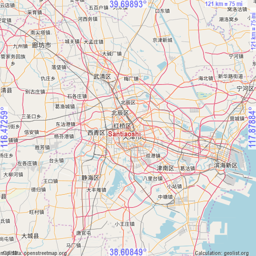
Santiaoshi GPS coordinates[2]
39° 9' 20.952" North, 117° 10' 32.556" East
| Map corner | latitude | longitude |
|---|---|---|
| Upper-left | 39.69893°, | 116.47259° |
| Center: | 39.15582°, | 117.17571° |
| Lower-right: | 38.60849°, | 117.87884° |
| Map W x H: | 121.2×121.2 km | = 75.3×75.3mi |
| max Lat: | 53.31946° ⇑16.5% North |
| Santiaoshi: | 39.15582° |
| min Lat: | ⇓83.5% South 18.22056° |
| min Long | Santiaoshi | max Long |
| 75.07348° | 117.17571° | 134.28917° |
| W 67%⇐ | ⇒33% E |
Elevation
Elevation of Santiaoshi is 7 m = 23 ft, and this is 477.8 m = 1568 ft below average elevation for this country.
| Max E: |
5622 m = 18445 ft | 94.3% |
| Avg. | 484.8 m = 1591 ft | |
| Santiaoshi | 7 m = 23 ft | |
Min E: |
-3 m = -10 ft | 5.7% |
See also: China elevation on elevation.city.
Geographical zone
Santiaoshi is located in North temperate zone (between Tropic of Cancer and the Arctic Circle). Distance of this Northern Tropic circle is 1747.8 km =1086 mi to South.| Distance of | km | miles | from Santiaoshi |
|---|---|---|---|
| North Pole | 5653.3 | 3512.8 | to North |
| Arctic Circle | 3047.5 | 1893.6 | to North |
| Tropic Cancer | 1747.8 | 1086 | to South |
| Equator | 4353.7 | 2705.3 | to South |


Nearby cities:
15 places around Santiaoshi: (largest is in red/bold)
• Chunhua
2.9 km =1.8 mi,  127°
127°
• Dahutong
1.2 km =0.7 mi,  154°
154°
• Dingzigu
2.6 km =1.6 mi,  322°
322°
• Guangfudao
2.4 km =1.5 mi,  115°
115°
• Guangkai
2.6 km =1.6 mi,  206°
206°
• Gulou
1.9 km =1.2 mi,  174°
174°
• Hongshunli
1.1 km =0.7 mi,  79°
79°
• Huayuandao
3 km =1.9 mi,  254°
254°
• Ningyuan
3 km =1.9 mi,  74°
74°
• Shaogongzhuang
1.8 km =1.1 mi,  267°
267°
• Tianjin
1.5 km =0.9 mi,  176°
176°
• Wanghailou
2.4 km =1.5 mi, 80°
• Xigu
1.2 km =0.7 mi,  329°
329°
• Xinkaihe
2.2 km =1.4 mi,  5°
5°
• Xiyuzhuang
2 km =1.2 mi,  305°
305°
Sources, notices
• [Note1] Compared only with cities in China existing in our database
• [Src1] Map data: © OpenStreetMap contributors (CC-BY-SA)
• [Src2] Other city data from geonames.org with taken over terms of usage.
• [Src3] Geographical zone / Annual Mean Temperature by Robert A. Rohde @ Wikipedia
