Dasheng geodata
Dasheng (Chongqing) is a seat of a fourth-order administrative division; located in China in Asia/Shanghai (GMT+8) time zone. In our database, there are 1268 cities with bigger population. Compared to other cities in China, 55.2% of cities are located further ↑North; 84% of cities are located further →East and 54.6% of cities have lower elevation than Dasheng. Note1


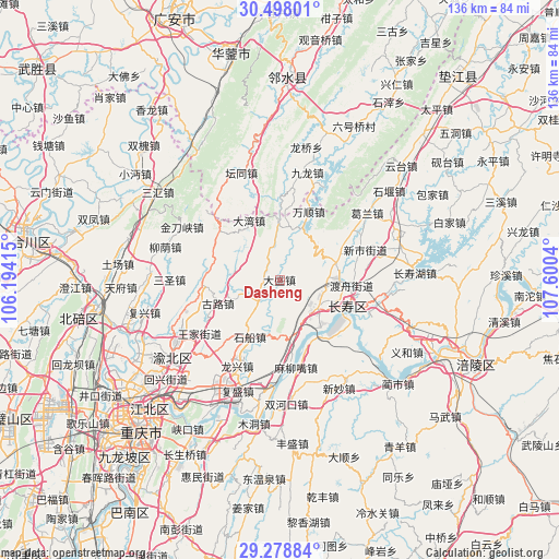
Dasheng GPS coordinates[2]
29° 53' 25.044" North, 106° 53' 50.172" East
| Map corner | latitude | longitude |
|---|---|---|
| Upper-left | 30.49801°, | 106.19415° |
| Center: | 29.89029°, | 106.89727° |
| Lower-right: | 29.27884°, | 107.6004° |
| Map W x H: | 135.6×135.6 km | = 84.3×84.3mi |
| max Lat: | 53.31946° ⇑55.2% North |
| Dasheng: | 29.89029° |
| min Lat: | ⇓44.8% South 18.22056° |
| min Long | Dasheng | max Long |
| 75.07348° | 106.89727° | 134.28917° |
| W 16%⇐ | ⇒84% E |
Elevation
Elevation of Dasheng is 203 m = 666 ft, and this is 281.8 m = 925 ft below average elevation for this country.
| Max E: |
5622 m = 18445 ft | 45.4% |
| Avg. | 484.8 m = 1591 ft | |
| Dasheng | 203 m = 666 ft | |
Min E: |
-3 m = -10 ft | 54.6% |
See also: China elevation on elevation.city.
Geographical zone
Dasheng is located in North temperate zone (between Tropic of Cancer and the Arctic Circle). Distance of this Northern Tropic circle is 717.6 km =445.9 mi to South.| Distance of | km | miles | from Dasheng |
|---|---|---|---|
| North Pole | 6683.6 | 4153 | to North |
| Arctic Circle | 4077.7 | 2533.8 | to North |
| Tropic Cancer | 717.6 | 445.9 | to South |
| Equator | 3323.5 | 2065.1 | to South |


Nearby cities:
15 places around Dasheng: (largest is in red/bold)
• Bake
12.2 km =7.6 mi,  84°
84°
• Cizhu
18.5 km =11.5 mi,  304°
304°
• Dawan
16.2 km =10.1 mi,  332°
332°
• Duzhou
17.5 km =10.9 mi,  94°
94°
• Fengcheng
17.5 km =10.9 mi,  113°
113°
• Gulu
16 km =9.9 mi,  249°
249°
• Honghu
13.3 km =8.3 mi,  23°
23°
• Jiangnan
17.3 km =10.7 mi,  128°
128°
• Luoqi
19.9 km =12.4 mi,  169°
169°
• Maliuzui
22.4 km =13.9 mi, 168°
• Shichuan
15.6 km =9.7 mi,  207°
207°
• Tongjing
6.3 km =3.9 mi,  233°
233°
• Wanshun
18.1 km =11.2 mi, 23°
• Xinglong
18.4 km =11.4 mi,  269°
269°
• Xinshi
21.4 km =13.3 mi,  68°
68°
Sources, notices
• [Note1] Compared only with cities in China existing in our database
• [Src1] Map data: © OpenStreetMap contributors (CC-BY-SA)
• [Src2] Other city data from geonames.org with taken over terms of usage.
• [Src3] Geographical zone / Annual Mean Temperature by Robert A. Rohde @ Wikipedia
