Shenglilu geodata
Shenglilu (Chongqing) is a seat of a fourth-order administrative division; located in China in Asia/Shanghai (GMT+8) time zone. In our database, there are 1268 cities with bigger population. Compared to other cities in China, 61.3% of cities are located further ↑North; 87.3% of cities are located further →East and 64.8% of cities have lower elevation than Shenglilu. Note1


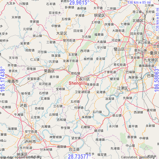
Shenglilu GPS coordinates[2]
29° 21' 1.728" North, 105° 52' 39" East
| Map corner | latitude | longitude |
|---|---|---|
| Upper-left | 29.9615°, | 105.17438° |
| Center: | 29.35048°, | 105.8775° |
| Lower-right: | 28.73577°, | 106.58063° |
| Map W x H: | 136.3×136.3 km | = 84.7×84.7mi |
| max Lat: | 53.31946° ⇑61.3% North |
| Shenglilu: | 29.35048° |
| min Lat: | ⇓38.7% South 18.22056° |
| min Long | Shenglilu | max Long |
| 75.07348° | 105.8775° | 134.28917° |
| W 12.7%⇐ | ⇒87.3% E |
Elevation
Elevation of Shenglilu is 321 m = 1053 ft, and this is 163.8 m = 537 ft below average elevation for this country.
| Max E: |
5622 m = 18445 ft | 35.2% |
| Avg. | 484.8 m = 1591 ft | |
| Shenglilu | 321 m = 1053 ft | |
Min E: |
-3 m = -10 ft | 64.8% |
See also: China elevation on elevation.city.
Geographical zone
Shenglilu is located in North temperate zone (between Tropic of Cancer and the Arctic Circle). Distance of this Northern Tropic circle is 657.5 km =408.6 mi to South.| Distance of | km | miles | from Shenglilu |
|---|---|---|---|
| North Pole | 6743.6 | 4190.3 | to North |
| Arctic Circle | 4137.7 | 2571 | to North |
| Tropic Cancer | 657.5 | 408.6 | to South |
| Equator | 3263.5 | 2027.8 | to South |


Nearby cities:
15 places around Shenglilu: (largest is in red/bold)
• Baofeng
18.4 km =11.4 mi,  245°
245°
• Chenshi
11.9 km =7.4 mi,  109°
109°
• Da’an
13.8 km =8.6 mi,  74°
74°
• Honglu
14.6 km =9.1 mi,  270°
270°
• Laisu
13.5 km =8.4 mi,  225°
225°
• Linjiang
14 km =8.7 mi,  146°
146°
• Longtanzi
18.4 km =11.4 mi,  335°
335°
• Nandajie
2 km =1.2 mi,  134°
134°
• Qingfeng
5.1 km =3.2 mi,  255°
255°
• Sanjiao
15.3 km =9.5 mi,  356°
356°
• Shuangshi
6.7 km =4.2 mi,  325°
325°
• Shuangzhu
10.6 km =6.6 mi,  166°
166°
• Yongchuan
1.6 km =1 mi,  77°
77°
• Youting
16.3 km =10.1 mi,  303°
303°
• Zhongshanlu
2.7 km =1.7 mi, 74°
Sources, notices
• [Note1] Compared only with cities in China existing in our database
• [Src1] Map data: © OpenStreetMap contributors (CC-BY-SA)
• [Src2] Other city data from geonames.org with taken over terms of usage.
• [Src3] Geographical zone / Annual Mean Temperature by Robert A. Rohde @ Wikipedia
